 |
 |
|
|---|
| Next Page |
| Previous Page |
Sunday 01 July 2007 - Canada Day
The rain continued overnight and thanks to our little shack we remained nice and dry. With no issues and an early night we were awake and on the road and hour earlier than usual. The overcast skies threatened to dump on us the whole time and we rode with our wet weather gear handy.
The road was relatively flat with the occasional 1-2% climb to ensure we didn't get it too easy. The bush right up to the road had us keeping a careful eye for wildlife. Todays ride was fairly non-descript except for the rain that fell causing us to cover up and ride in it, the passing parade of very large motorhomes spraying us as they drove North on their summer adventure.
Arriving at the Johnson River, a half kilometre wide waterway we rode across the long bridge and were surprised  to find ice still along the bank. The light brown water flowing quite quickly and gradually covering the river bed gradually reducing the dry areas to small islands.
Some kilometres on, and about 30 kilometres from Tok (pronounced Toak as in Tokyo) we came to Moon Lake State Campground, so as it was time for lunch we decided to investigate it as a possible campsite. The campground was quite nice, but at $15 per night with only a toilet and no showers, we decided to enjoy lunch looking at the lake and float plane parked there and then continue on towards Tok.
Arriving in Tok as the rain began to fall we rode through the very long and spread out town to the tourist information centre where we investigated our accommodation options, eventually deciding on a small motel on the outskirts. A quickstop at the only store in town we rode onto the motel and after checking in, enjoyed a dry night, TV and free Wi-Fi (when it works).
Today's Stats
From: Dot Lake
To: Tok
Ride Time:
5 hrs 56 mins
Distance:
81.16 km's
Av Speed:
13.60 km/h
Max Speed:
45 km/h
Max
Altitude:
598 m
Av Climb: 2 %
Max Climb: 11 %
Weather: Overcast and rain. 14-21 Deg C.
Camp Location:
N: 63:20'11.5
W: 142:59'17.2
Monday 02 July 2007
With thunderstorms brewing in the area and neither of us feeling like riding we decided to take a day off and spend it inside a motel. Of course once we were in the room the sun came out and a tailwind topped off the weather, but then around 4.30 pm the rainstorms hit knocking out all satellite TV and Internet, leaving us thankful for being inside and hoping for a good days ride tomorrow.
Tuesday 03 July 2007
Leaving Tok early this morning we had hoped to get some decent distance in today so as to make the trip to Chicken as short as possible. Tok was still waking up as we left town, our early morning departure rewarding us with two moose crossing the road not far in front of us. About 9 km's out of town we came to the vehicle weigh station that Dirk and Petra had told us about. Stopping and asking if we could be weighed resulted in both of us sitting in our trikes on the pad until told that we had been recorded. Joanne, her trike and equipment came in at 150kg (340lbs) and Pip, me, the equipment and trailer registered 170kg or (380lbs).
After enjoying our chat with the weigh station operators we rode on until we came to Tetlin Junction, a deserted and run down cafe, motel, cabins, petrol station, and the turn off that would see take us towards Chicken, the Canadian Border and the Top of the World Highway.

A brief inspection of what would have been a nice wayside stop in days gone by we commenced the trip up to Chicken. The road turned upwards and immediately had us searching for granny gear. Dirt patches along the side of the road where the road had been cut out of the hill were decorated with messages and peoples names made out of rocks, providing us with reading material and something to take our minds off of the hill.
Climbing and climbing we slowly pulled ourselvves up each hill, the view of the surrounding countryside getting better and better, many trees standing like ghosts of the past where bush fires raged through the area some years ago, the only colour being provided by the green bushes starting to grow and the bright pink of the fireweed.

The further we went the closer we got to the dark clouds and rain that was building over Mt Fairplay and the surrounding area. Wet weather clothing at the ready we climbed and climbed, the days total climbing topping out at 1,200m. Coming to the top of a hill and with stomachs grumbling like an earthquake, we decided to enjoy lunch at a turnout over looking many of the hills we had climbed, and those we were yet to climb. Hot drink made and food being eagerly devoured, we noticed the rain starting to come in from a number of fronts, edging closer and consuming our sight of the ridges and hills until it they were not visible and it upon us. Hastily packing up and getting our wet weather gear on we noticed that we were only going to get the tail end of the rain, so decided to continue riding in the hope of missing it all together.
A number of kilometres later we stopped to take the hot wet weather clothing off, the dark grey rain laden clouds all around us and thunder and lightening crashing overhead. Thinking we had missed the lot we continued on, and then, almost as if to spite us, another storm front came in and immediately dumped on us. With just enough time to get the raincoats on we were being well and truly pelted with rain, people driving past obviously thankful for being inside their vehicles and wondering why on earth we would be riding. Adding the wet weather trousers to our garb we continued to ride on in the rain, reasonably dry and generating heat through climbing the hills.
As Mt Fairplay came into view, rain clouds covering the summit, and I distinctly remembered thinking, "I am glad we won't be going up there..." so there are no prizes for guessing where the road took us! We climbed and climbed and climbed, eventually topping out at 1,144 m, some 400m short of the summit. Rain began to fall, the temperature dropped to 13 deg C and we were getting cold and rather hungry. Stopping at a turnout with an information deck and outhouse, we decided to cook our evening meal and then put the tent up. Using the outhouse as a wind and rain break (thankfully it had no smell), we cooked and ate our meal as the rain began to really set in. Meal over we were debating about how to get the tent up without getting it too wet when a car pulled up and a lady went to use the outhouse. Noting the car had come from the direction that we were heading in, Joanne quizzed the woman as to the weather further down the road. "Fine about 4 miles on" was her reply, so we decided to ride on and see what we could find.
Rain falling and a wet road made for interesting riding, especially as we were now decsending, corners becoming slippery and interesting. Following Joanne  down the hill making sure I was to one side to miss the spray off of her rear wheel when she rode through a very large puddle, sending the contents flying and straight into my face, emulating a comedy sketch on TV, she couldn't have done a better job if she had tried and we both had a good laugh over it.
We descended quite away and eventually rounded a corner to see the whole side of the hill in front of us and for some way ahead, covered in bright pink fireweed, courtesy of the lack of trees because of past fires, it was an amazing sight and one that we might have enjoyed more had it not been wet and miserable. The closer we got to the pink hill, the less the rain fell and had stopped by the time we spied a track leading off to a small area next to Logging Cabin Creek. A quick investigation revealed a nice campsite area near the creek, an old fire place and a table and chairs. With no sight of any bear activity we declared the days ride over.
Today's Stats
From: Tok
To: Logging Cabin Creek
Ride Time:
7 hrs 37 mins
Distance:
87.20 km's
Av Speed:
11.4 km/h
Max Speed:
64 km/h
Max
Altitude:
1144 m
Av Climb: 3 %
Max Climb: 11 %
Weather: 13-21 Deg C. Sunny then rain
Camp Location:
N: 63:48'10.5
W: 142:12'47.4
Wednesday 04 July 2007 Independance Day USA
Overnight two vehicles came into our little camp spot, presumably looking for a campsite, the not sointelligent driver of one tooting his horn as he left, leaving me to hope that road Karma would repay him at some stage. We awoke to a grey 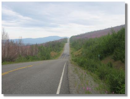 skies all around except in the direction we were going which we thought might be a good omen. The road was still making us work hard, the views of the valleys below the road and surrounding ridges giving us something to look at, not to mention the copious amount of fireweed giving the place a real pink tinge.
The many hills and gravel sections where the road has supposedly been repaired made the ride interesting and challenging, it seemed like we were going nowhere fast and like our destination was so far away. We are not sure why the day was becoming so unenjoyable, but it was and seemed like a real slog, the trike seeming like a slug and no matter what we did the ride was becoming a real chore.
Climbing up one of the many steep gravel sections we noticed headlights coming towards us, and one set became two, and two became three, a convoy of motorhomes, campers and the like were all headed towards us,  so seeing that many of them often take our photo, I decided to take theirs, and some video as well, causing many of them holding their camera's to laugh as they passed and presumably taking a photo of us taking their photo.
Fun over it was time to continue the work and get ourselves closer to Chicken, a small town founded by gold miners who wanted to name their town after a Ptarmigan, one of the local birds, but as they couldn't spell the name they just named it Chicken as that's what the bird tasted and looks like.
Today is the American's Independance Day and it seemed like everyone was going to Chicken to celebrate it. Approaching the town we descended down a very steep hill, and would have broken our trip speed record but for the bumps and corner halfway down, discretion rather than valour causing brakes being applied to control our speed through the corner to ensure that we didn't smear ourselves across the road and arriving in town like Chicken roadkill. With about three kilometres out of town the road turned to dirt and we struggled into town, many RV's passing us as we did. Most places here were busy with all the tourists and Independance Day revellers, so we rode down to the RV park and managed to get one of the last tent sites. The rest of the place taken over by large RV's, campers, many from the Anchorage Gold Miners Associaton.
Camp set up and the order of the day was browsing the cafe's souveniers, lunch and use of the free Wi-fi (when the Satellite works), then a shower (75c for 1 minute) before sitting at camp drying some of our gear out and watching the thunderheads build up over the range behind us, all the time making us guess if we would get a drenching or not and ensuring that we were packed up and ready.
Being one of America's most important days means that the town will be in party mode tonight, fireworks already being tested and no doubt throngs of patriotic drunken people will be trying to walk around tonight, thankfully, we are situated far enough away from all of that, though it should be worth a laugh if we decide to take a peek. We were warned that there is an old gunpowder cannon up the hill, so it will be no surprise to hear that booming out at some stage. There are a few sights to see around Chicken, including the old shops, townsite and gold dredge, so we will be taking a day off tomorrow to explore around the place and give the legs a rest before we tackle the hill out of town and up to the Canadian Border and the dirt road to Dawson City, some 180 km's away.
Today's Stats
From: Logging Cabin Creek
To: Chicken
Ride Time:
3 hrs 28 mins
Distance:
39.10 km's
Av Speed:
11.2 km/h
Max Speed:
69.5 km/h
Max
Altitude:
832
m
Av Climb: 4 %
Max Climb: 11 %
Weather: Deg C.
Camp Location:
N: 64.04'05.2
W: 141:56'32.6
Thursday 05 July 2007
It's not often that you get to spend a special day like Independance Day in a place like Chicken and miles from anywhere or anything, so we took the short walk up to the party, finding on our arrival plenty of people doing what people do at party's - drinking, dancing and being somewhat liberal with their activities. There was a band playing typical bluegrass music and entertainment with guitars and banjo's. We took a look inside the Chicken Emporium where we evened out our travelling weight by swapping some American Dollars for some souveniers. There we were just minding ourown business amongst all manner of Chicken related cups, plates, shirts, stickers and the like when there was this almighty bang. Yep, someone had lit the fuse on the old gunpowder cannon and in typical Chicken style, granted the final request of an old Chicken resident by shooting his ashes out of the cannon all over the carpark on the 4th of July. Strange sort of request, but somehow fitting with the place and people that are here. Chicken has a population of around 50 during the summer, and 15 during winter.
Walking back to our tent after the excitement of the party it occured to me that what I thought was testing of fireworks was in fact the fireworks show, though why you would want to set up and set off an elaborate fireworks show in broad daylight was beyond me! Don't you need darkness for a truly great fireworks effect? Still, this is Chicken, a place like no other, and one that is as interesting as it is quirky. The music finally died around 2 am and Chicken went off to roost.
This morning we took a walk around town, firstly up to the Post Office (circa 1903) and then down to the other  fuel, campground, souvenier shop before heading back to the 3 shop commercial centre of town where we enjoyed lunch. Being short of $1 notes I offered to swap 10 of ours for a $10 note, well, that got the desired result and as a present for being so helpful I received a free Chicken, Alaska pencil - truly a keepsake to remember the place by.
So after the excitment of last night, the touring and shopping this morning, not to mention the rain clouds and short downpour we had, we have spent the day relaxing, conducting trike maintenance, re-packing the trailer and waiting for the clouds to clear so the satellite Internet would work. Life is pretty simple here in Chicken.
Check out the fun website on Chicken here, or the place we stayed at here.
Friday 06 July 2007
Leaving Chicken meant first climbing a rather large hill, followed by about 20 kilometres of riding up and down as  the road followed the contours of the hills to remain high above the river below. We eventually descended to river level and were immediately in mud created by the rather strong rainstorm last night. Riding was down to a snail's pace as the wheels sank into the mud, the mud guards filling with mud and dropping it all over the wheel, spokes and of course gears and brakes at the same time it was dropping out the back of the guard like a sausage. Thankfully the mud didn't last more than a kilometre and a climb away from the river provided us with some magnificent views of the area and of the river far, far below.
Evventually descending to river level yet again we came to the rusting hulk of the Jack Wade Number 1 dredge where we enjoyed lunch next to the fast flowing but chilly water of the river. Lunch over we again began climbing and climbing, beatiful vista's of the surrounding ridges and the river below to take our minds off of the climb.
Eventually arriving at a small settlement named Boundary, one of the first roadhouses in Alaska, we found an airstrip and some ramshackle buildings which when open, act as a roadhouse and saloon. Numerous vehicle number plates adorning many of the buildings, snowmobiles, bicycles, vehicles and all sorts of stuff lying around the place but with nobody to be found except us, a Japanese cyclist named Hiro and some other tourists, it was almost as if the occupants of the place had just driven off leaving the place to whoever turned up. Some of the buildings were locked, but in general the rest were left open. Three shacks were there, complete with personal effects and ready waiting for occupants, but again, no people. We had hoped to stay there and truth be known could have just moved into one of the shacks, but it didn't seem right, so we cooked and enjoyed our evening meal while fighting off the mozzies before riding on.
The rain clouds that had been building hed decided to dump on us and the rain set in causing us to don the necessary clothing, but it is so uncomfortable and hot climbing hills in this garb that we ended just as wet as if we hadn't put it on. Reaching the Davis Dome lookout in pouring rain we decided to try our luck at the US/Canadian Border a further kilometre on, perhaps they would let us camp behind a building of something. Reaching the border gate we found two border officials talking to a man who was putting his tent up just outside the big iron gate that is across the road after 8pm. The guy was hiking and like us had made it to the border too late to proceed. We had a brief chat with the officials (who promised us coffee in the morning) before heading back down  the road to the Davis Dome rest area. Luckily for us the rain eased enough for us to put the tent up and get inside to warm up.
Both of us were wet and cold and too much longer outside would have seen the effects of hyperthermia setting in. So, with wet clothes hanging inside the tent in a vain attempt to dry them, we very thankfully pulled the sleeping bag over us and fell asleep. We have had rain everyday for the last week, so despite our best efforts, and pannier raincovers, much of our stuff is wet or damp, and the continual wetness is starting to annoy us, but this is sumer here and that is when they get their rain, so we can expect more of this weather and will have to find new ways to dry things off or improve the way we keep them dry.
As we leave Alaska we thought it approapriate that we have a final word on the place - we love it. Neither of us were sure why Alaska really came into the trip equation other than my idealistic notion of taking on and riding in one of the final frontiers on earth, but after visiting and riding through it, both of us have found Alaska physically and mentatlly challenging, and visually spectacular - so much that we want to come back (not by trike). We want to investigate and experience more, especially around late winter, early spring. Alaska has left an incredible impression on both of us - it is simply an amazing place.
Today's Stats
From: Chicken
To: Davis Dome
Ride Time:8 hrs 9 mins
Distance:
69.86 km's
Av Speed:
11.2 km/h
Max Speed:
55
km/h
Max
Altitude:
1315 m
Av Climb: 4 %
Max Climb: 20 %
Weather: Sunny then rain 30 - 13 Deg C.
Camp Location:
N: 64:05'12.7"
W: 141:00'44.9"
Saturday 07 July 2007 - Leaving the US and back in Canada
Waking to rain falling we began to pack up inside the tent not relishing the day ahead if the weather continued like it was, but by the time we were ready to get out of the tent the rain had stopped. Quickly packing up without rain falling enabled us to take some time to appreciate the magnificent view that had started to become clear as the cloud moved through the valley and around Davis Dome and the sign welcoming us to Alaska.

After a nice chat with a woman in the caravan parked behind where we set up, we began riding back up to the  Border, and the coffee that was promised last night. On arrival we were met by both the Canadian and US border officials and enjoyed a chat about our trikes and trip with them. Moving into the office to conduct the official part of the visit, our passports were stamped, we were processed as visitors to Canada and then we were invited in for that coffee as promised.
Rod, the Canadian Official and Tom, the US Official were very good to us and not only gave us coffee but allowed us to pinch some donuts as well. Hiro, the Japanese cyclist was there and departed not long after we arrived.
Enjoying the hospitality and chat for around two and a half hours, we partook in some more coffee, viewed the border marker on the side of the hill, the plaque on the side of the building denoting where the border cuts the building in half, and had a photo taken straddling the blue line (denoting the border) across the floor inside the building. Ready to head off we filled our water bags, thanked Rod and Tom, and rode off.
Thank you Rod and Tom for your professionalism, hospitality and friendly manner, we appreciate it.
Of interest is the fact that when the river at Dawson City freezes and the ferry cannot operate, the top of the world highway stops being maintained and the road and border crossing close. The road is impassable except on snow machines - if your mad enough to attempt it.
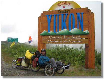
The cloud had started to clear so after leaving the border post we rode over to the sign denoting the start of the Yukon and took our "been there, done that" photo's. Leaving the sign we commenced the long climb to the highest point on the Top of the World Highway. A quick check and adjustment of the brakes and we started off with a downhill run for quite a few kilometres.

The view from the top and down the downhill just magnificent, the ridges out in the distance, the barren landscape and the clouds seemingly closer than anything around us really made us feel like we were on the top of the world.

The road ahead
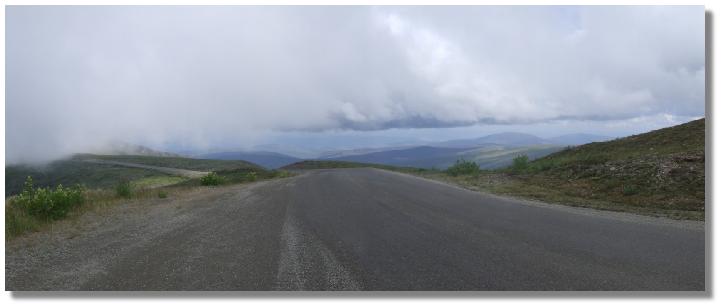
The road and border crossing behind
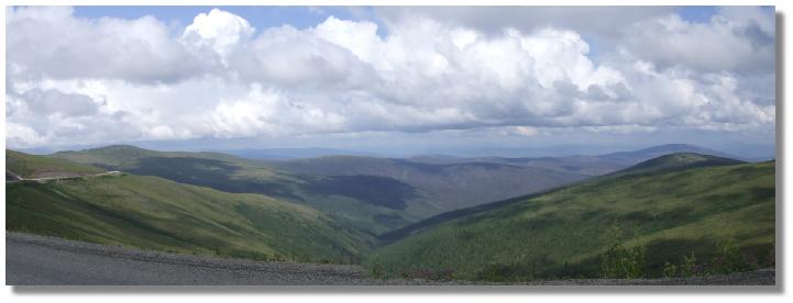
Some of the many vista's we enjoyed

The top of the world view continued when we came to an old survival shack, it's sod covered roof caved in, and the bush slowly taking it over. Enjoying lunch here we had just finished when we were again forced to don wet weather clothing as the rain clouds all around us came in and began to dump on us. Riding on, up hill and down dale, the view from the top of the world was diminishing as we came into more and more trees, bush and valleys as we were gradually descending. And then it happened, the heavens really opened up, the rain pelting down, reducing visibility and with suchforce that the raindrops were bouncing a couple of inches off the dirt road. Suddenly the temperature plumetted and before we knew it we were being pelted by hailstones the size of peas and all the time while climbing yet another hill. The good news is that we were dry and warm inside our wet weather clothes, they had done their job and justified their expense yet again.
Hailstorm over we began up another hill that would see us regain all of the altitude that we had lost. This time, the hill was on gravel, the sign informing us of 10km of Gravel Patches, but in truth it was 10 km of pavement patches, the size of a cobblestone and making the 13% climb very hard and slow, the rear wheel often slipping on the loose gravel resutling in wasted energy.
Turning back to sealed road near the top of the two kilometre climb meant that although we were still climbing, it 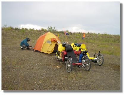 was slightly easier. Arriving at a flatter area we noticed a gravel area off to the left of the road just before another climb, so with more rain clouds building we decided to call it a day and set up camp some 25 metres from the road just before the rain came in.
It had been quite a day, and one that was made better by the wonderful hospitality at the border and the magnificent views we enjoyed along the way, with the expectation of more tomorrow - rain and clouds permitting.
Today's Stats
From: Davis Dome
To: Gravel Pit
Ride Time:
3 hrs 59 mins
Distance:
42.55 km's
Av Speed:
10.6 km/h
Max Speed:
69
km/h
Max
Altitude:
1381 m
Av Climb: 4 %
Max Climb: 13 %
Weather: 11-18 Deg C. Rain and hail with occasional sunny breaks.
Camp Location:
N: 64:11'17.8"
W: 140:22'34.8"
Sunday 08 July 2007
The rain eased overnight and only a couple of showers came through. Waking to a dry and clearing morning we used the morning sun to dry some things out before heading off for some more hill work and enjoyable views.
Todays ride was uneventful but the beautiful scenery continued, as did the hills. The road was a mix of gravel and tar, more gravel than tar and when it was sealed there were plenty of pot holes to dodge. Cresting the tops of the hills allowed us to see the road off in the distance and it was fun to try and work out where it was going to go.
We were making slow progress and it looked like we might not make Daswon City today, but as things often do  after lunch, the road and our riding improved and before we knew it we were at the outskirts of Dawson, a makeshift building with tourist information on the inside welcoming us to the area, and it was here that our magnificent views began to diminish.
We coasted down the 14 km long 6% grade, thankful that we were going down and not up. It would have been so easy to just let the trike have its head and hurtle down at breakneck speed, but we descended under brakes, savouring every last view from the top of the world, and of course taking time to read the advertising boards as we edged closer to town.
Arriving at a small lookout on the side of the road we were able to catch our first glimpse of Dawson City, nestled beneath the surrounding hills and along the rivers edge.

Eventually reaching the bottom of the hill we took the free ferry across the river and arrived into town, and what a town! The buldings look like they are straight out of a Western movie, the wooden planked footpaths and dirt roads, tall fronted wooden buildings and that frontier look and feeling, the only things missing were the people in period costume and horses and cowboys rather than vehicles- it is an amazing place and has an amazing feel to it.
We had decided to take some accommodation here in Dawson CIty and to enjoy a little luxury, the State campground on the other side of the river looked nice but lacked things like a shower, so rather than camp there and go into town to the RV park for a shower etc we ended up taking the easy option and a room at a place called the Bunkhouse.
A final word on the Top of the World Highway. Although not quite as tough or as long as the Dalton Highway, the Top of the World Highway is still a tough road to cycle and it is no surprise that it is closed during winter. The continual changes in altitude and in our case - weather, made for a very challenging ride which not only tested us physically, but mentally. Having said that, the view from almost all of the road is, in one word - spectacular! Like most spectacular places, photographs and descriptive text cannot do any justice to what the human eye can register.
Anyone wishing to follow in our tyre marks should note that there is nowhere to obtain grocery items along the road, and water is similiarly rare so be prepared to carry both. It is possible to obtain water from rivers and streams at lower elevations, but is almost non-existant at higher elevations which the road is at for most of the time. Water is available at Chicken in limited quantities and possibly Boundary whenit is open. So, was the trip worth the effort, and did we enjoy it? - You bet!
Today's Stats
From: Gravel Pit
To: Dawson City
Ride Time:
5 hrs 32 mins
Distance:
67.06 km's
Av Speed:
12.10 km/h
Max Speed:
56
km/h
Max
Altitude:
1236 m
Av Climb: 3 %
Max Climb: 12 %
Weather: 15-28 Deg C. Sunny/overcast.
Camp Location:
N: 64:04'05.3"
W: 139:27:05.7"