| Next Page |
| Previous Page |
Monday 15 January 2007
Yesterday afternoon Caloote Landing was a flurry of activity as many visitors, or those just visiting their shacks for the weekend made the most of the good weather and the river. The many boats, skidoo riders, water skiers, knee boarders, houseboats and all other manner of craft that were all out there enjoying the river as we sat there enjoying their antics, but as dusk set upon the river the peace and tranquillity returned once more.
We again fell asleep to the lapping water and awoke to an overcast sky and more quiet, well, except for the flock of galahs that had taken roost in a tree nearby and who, heralded by one ring leader, were waking the world for another day next of life on the river. Morning wake up call over, it was time to just remain in bed, listen to the morning bird life and soak up the ambiance and the fresh, cool morning air blowing through the tent. Caloote Landing was so very quiet and peaceful and it was so tempting to just sit on the bank and stay another day, but other tasks were upon us.
We packed up and began to ride off when one of the locals
told us the paddle steamer the Murray Princess would be
 along
soon, so wanting to get her on video we postponed our departure.
along
soon, so wanting to get her on video we postponed our departure.
Looking up the river we could eventually saw her bow round the bend, low in the water and her superstructure towering above the river with the distinct sound of the paddlewheel at the stern churning up the water. As she steadily made her way to our vantage point a small boat came out from alongside her and sped over to the landing area near us, picked up a passenger and returned whence it had come.
We managed a small video and just in the nick of time as the camera batteries, which had been first put in in Norseman, decided to give up the ghost, the reserve set flat and also in need of re-charging via the solar panel.
We climbed up the hill and out of Caloote Landing, passing Ray the man who provided us with a shower yesterday, and who was out for a morning walk. Once on the main road and after climbing some more, we descended until we came to a bridge, which after crossing, we turned right up another dirt road. We had been told that the road followed the river to Mannum and was a good way to stay off the main road, and it was. Passing through more dairy country and not as close to the river as we would have liked, we eventually came to the town of Mannum where we are spending a day for showers, laundry, shopping and the like before we continue on.
Mannum was founded by Captain William Randell, a sea Captain who built his own shipping line, and operated steam powered ships out of the area. Mannum is also recognised as the birthplace of the Murray Paddle Steamer with many of them being and operated from here.
UPDATE: The previous page now has a link to a map of our travels. Where possible we will include one at the bottom of each page.
Today's Stats
From: Caloote Landing
To: Mannum
Ride Time:
1
hrs 19 mins
Distance:
16.25
km's
Av Speed:
12.2
km/h
Max Speed:
44
km/h
Max
Altitude:
107
m
Max Climb: 4 %
Av Climb: 11 %
Weather: Sunny 28 deg C.
Tuesday 16 January 2007
Leaving Mannum we took the free ferry across the river and after inspecting one of the free campsites on the other side continued on our way along the river via the scenic tourist drive. Along the way we came across a Marina for houseboats for hire, purchase or store and a short while later came to a small place called Younghusband. It was here that we took up a position next to the boat ramp in the shade and opposite the general store for a morning tea break.
The weather began to heat up again and before we knew it the temperature was in the mid 40 deg C range, so after some 30 kilometres, and now on a dirt road, we stopped for lunch under some some shady trees overlooking the river. To add to the shade we fixed the hootchie in the trees and waited the main heat of the day to pass. The only problem with our spot was that it was high up on the cliff and nowhere near the river where we could get access to the water to cool down. So, like our 51 deg C day on the Nullarbor we took the decision to ride on towards Bow Hill which we estimated to be around 8 kilometres away, and this 8 kilometres was indeed hard, especially with the the air on the road being 49 deg C as we rode.
On the way to Bow Hill we again passed some more river
scenery, this time small lakes on the side of the river the
 banks
of some being built on.
banks
of some being built on.
Arriving in Bow Hill we took a wrong turn and rode down the road passing the 141 riversideshacks, the heat was causing the tar to bleed and pop under our tyres. Getting to the end of the road we turned and after getting directions from a local, we eventually arrived at the general store. We immediately partook of cool drinks from the general store before heading down to the river to cool down.
At the General Store we were met, escorted, entertained and finally pestered by the most talkative 5 year old we have ever met - Riley. Riley followed us everywhere asking every conceivable question under the sun about us and the trikes, and then some, and he even followed us into the river!
After cooling down somewhat and with the clouds moving in we decided not to camp at Bow Hill and rode on until we arrived at the town of Purnong, another little settlement on the banks of the river. Noticing some people parked and looking like they were camping we asked them about it. They were camping but did not know what the legal situation was so we asked the driver of the Ferry, who promptly told us we could camp anywhere on either bank - so we did. We took the ferry across to the other side where we managed to locate a nice campsite complete with small pebble beach giving easy access to the river, and with a toilet block close by. The weather was still very hot and muggy so we cooled down in the river and even cooked and ate on the small pebble beach, all the while enjoying the coolness of the river before retiring to bed.
Today's Stats
From: Mannum
To: Purnong
Ride Time:
4
hrs 33 mins
Distance:
58.1
km's
Av Speed:
12.70
km/h
Max Speed:
50.5
km/h
Max
Altitude:
213
m
Max Climb: 3 %
Av Climb: 15 %
Weather: Hot & Sunny 49 deg C.
Wednesday 17 January 2007
As we lay in the hot tent last night the cool change came through sweeping the heat of the day from the land and cooling the tent nicely for sleeping, and we awoke to a cool, overcast day. Packing up and taking the ferry back across the river we climbed the steep dirt road out of town and back to the main road.
Passing near Walker Flat we took the turn and the short ride down to the lookout which gave us a nice view of the river, houses and general store and surrounding farmland. Back to the main road and more riding through very dry farmland and on towards a number of lookouts over the river with the riverside cliffs becoming more and more prominent on both sides, the most notable being the Big Bend lookout which boasts the highest cliffs along the Murray.
As we approached the small location of Nildottie we passed some of the onion crops which the area is known for, including a sign that indicated it was Duff Creek, the original home of Onion Breath, as used some time ago in the TV advert for chewing gum.
Passing onto Swan Reach we rode through some very dry and
Nullarbor-ish terrain before we finally arrived in the
 small
town of Swan Reach where we partook of lunch in the park overlooking the
river.
small
town of Swan Reach where we partook of lunch in the park overlooking the
river.
Swan Reach, like many river side towns has had its fair share of floods, the most devastating being in 1956when most of the main street businesses were washed away.
A short ride and a ferry trip and we were at the Tenbury-Hunter Reserve, a free camping area opposite some river cliffs. We promptly selected the best site and spent the rest of the day relaxing and enjoying the river.
Today's Stats
From: Purnong
To: Swan Reach
Ride Time:
3
hrs 11 mins
Distance:
45.7
km's
Av Speed:
14.2
km/h
Max Speed:
40
km/h
Max
Altitude:
131
m
Max Climb: 3 %
Av Climb: 13 %
Weather: Overcast and cool then sunny and 31 deg C.
Thursday 18 January 2007
Our riverside camp last night was peaceful and we were
the only campers there. As we retired to bed we kept a
 watchful
eye on the cliffs opposite to see if they would provide a spectacular sunset
picture, and whilst they did not provide a winning shot, they did provide a
pleasant view.
watchful
eye on the cliffs opposite to see if they would provide a spectacular sunset
picture, and whilst they did not provide a winning shot, they did provide a
pleasant view.
We woke early and got on the road, crossing the river again on the ferry. Once back on the other side we spent a few minutes reading the plaques outside the hotel and riverside general store. The road out of town from the general store was so steep that we re-traced our steps from yesterday and took a longer but less steep way out of town.
The weather was overcast and threatening but was very humid, making the riding a little uncomfortable. The road was reasonably flat and we were making good progress. Following the river but along the top of the cliffs we stopped every now and then to view the river and in some cases, the shacks that people had near the waters edge and which would be lost during any flood.
We arrived on the outskirts of Blanchetown, location of the first of 14 locks along the river and one of a few that has abridge over the river and not a ferry. The closer we came to the bridge we could see that it was a long one and all uphill from our end because of the cliffs on the other side. Bypassing the town (and the bridge) we followed the Sturt Highway for a while and with the amount of traffic we quickly realised that the quiet river roads we had been taking had spoilt us. Turning off towards Morgan we again recaptured the quiet easy riding.
The weather was closing in and despite brief glimpses of sunshine the rain began to fall just as we rode into the locality of Murbko. Noticing a small church and hall we decided to find a spot to have lunch next to it. Just as the kettle was boiling the rain intensified so we adjourned to the front porch of the hall where we sat, with the trikes, under the porch, ate lunch and had a little rest while the rain fell.
Around 2pm the rain let up and we decided to ride on towards Morgan. The road was a real roller coaster and passed through some very dry country, the sand showing through and making us wonder how anything grew there, and just as we were wondering that we came to a huge apple orchard.
Approaching Morgan we came to an intersection where we found a man on a motorbike with a small dog in his shoulder bag. He was lost, claimed to have no money and be running out of petrol. He was just muttering that he just didn't know what to do or where the place he was looking for was. We got our maps out but were unable to assist him, suggesting that he ride into town where he could ask, but he wasn't interested in that. He left and we turned off down the dirt road heading towards a Conservation Park where we hoped to camp. Riding through the park we came across the man on the motorbike again and he was just as lost as last time. So with the rain starting to come down and finding nowhere to camp we took the ferry across the river and took a cabin in the caravan park. It was not our desired end to the day but you get that sometimes.
Today's Stats
From: Swan Reach
To: Morgan
Ride Time:
5
hrs 2 mins
Distance:
70.5
km's
Av Speed:
13.9
km/h
Max Speed:
37.5
km/h
Max
Altitude:
113
m
Max Climb: 10 %
Av Climb: 2 %
Weather: Overcast
Friday 19 January 2007
Yesterday we asked about a two day stay when we booked into the caravan park only to be told that they were all booked out. Resigned to the fact that today was going to be wet and us with it we handed the key to our cabin back in, only to be told that now there was a cabin available. Noting the weather and the forecast for more of the same it was an easy decision to take the second day and turn it into a rest day. So while our new cabin was being prepared we we would follow the historic walk around town.
The historic walk started near the river at the old Mortuary which was erected in 1886 and it is here that whilst assisting with the preparation of the ground that Royal Navy Surveyor Harvey speculated as to who would be the first occupant, only to drown the next day and thus provide the answer to his own question.
Our next stop was the old Morgan Railway station that is now a museum, and despite the rails having been removed, the area where they were is still visible, as is the railway bank further on where it passes behind the caravan park and where the bridge went over the road. The old railway station is near the remaining part of the paddle steamer wharf and during the height of the paddle steamer trade (1880-1915) was the terminus for six trains per day, testament to the fact that Morgan was the busiest inland port in Australia. The remaining part of the wharf shows little of the red wood structure that was originally 168 metres in length and had water hydraulic cranes and gangs of up to fifty men working 24 hours per day to unload the wool, wheat and other goods that the paddle steamers would bring to Morgan to be sent to Port Adelaide by train.
So after taking a look at the town and its 41 points of interest we stopped at the supermarket for supplies and returned to the caravan park where we spent the rest of the day conducting trike maintenance, cleaning, drying of wet equipment and resting, and, at the time of writing the rain is nowhere in sight and the sun has even been out. Typical!

Todays Stats
From: Morgan
To: Morgan
Saturday 20 January 2007
One of the great things about having mobile Internet is the ability to check the weather radar from the Bureau of Meteorology website, and looking at it this morning gave us an indication that there was some very severe storms heading our way. Unfortunately for us, the cabin had been booked and so we had to vacate and make a decision as to what we would do - find some other accommodation; put the tent up; or ride the 40 kilometres to Waikerie and see what we could find there.
We sat under the roof overhang at the public toilets while we figured out what to do. A local man came and had a chat with us and gave us some good information on the roads and campsites along the river. Figuring we had some time before the rain hit we took the ferry back across the river and off towards Waikerie.
Light rain bean to fall as we rode and before long we were climbing a few hills near Cadell. The closer we got to Waikerie the more citrus orchards we came to. The rain began to come down harder and we stopped to get our coats on. A roller coaster road for the last 10 kilometres into town before a long climb up into town. TV reception is obviously an issue through the Murraylands because like most places we have been, Waikerie residents have exceptionally tall masts with their aerials on the top.
Wanting to get some supplies we rode past the caravan park and the ferry and up into town. We were also looking for the tourist information centre. Almost out of town on the other side we decided to ring the caravan park to see if we could get in, but we couldn't, so we tried to call the motel/cabins only to get their answering service. Finally we rode on towards the tourist information centre and found the motel/cabins so we booked in, rode back to the supermarket and just got back to the cabin in time before the storm really hit.
Today's Stats
From: Morgan
To: Waikerie
Ride Time:
3
hrs 5 mins
Distance:
43.3
km's
Av Speed:
14.0
km/h
Max Speed:
51.5
km/h
Max
Altitude:
220
m
Max Climb: 16 %
Av Climb: 2 %
Weather: Overcast, raining, 23 deg C.
Sunday 21 January 2007
Cyclists love a tailwind as we awoke to one this morning. The radar on the met site showed no rain near us or our destination so things were looking up. A river crossing courtesy of the South Australian Government and we were on the other side away from the Sturt Highway and its traffic.
We were making good speed with our tailwind and before
long had arrived at the Overland Corner Hotel which was built
 by
three of the Brand brothers in 1859. It was also in this area that the
explorer John McDouell Sturt obtained his horses for his expeditions.
by
three of the Brand brothers in 1859. It was also in this area that the
explorer John McDouell Sturt obtained his horses for his expeditions.
As it was near lunchtime we stopped at the hotel and quenched our thirsts with a few ales and lemon squashes while inspecting the building and its displays which included items from when the hotel was the Post Office, and when the bushranger Captain Moonlight rode his horse into the bar after he and his men locked the only Police Constable in the area in cells and shod his horses courtesy of the Government. Drinks over we rode down the rode away where we enjoyed lunch before rejoining the main road.
Some kilometres later we arrived at the turn off to Barmera and Lake Bonney, a natural lake fed by the Murray River and which, to the protests of the locals, looks like the Government will shut off from the river to provide more water in the river, effectively giving life to the river and killing the lake, its wetlands and town access. If you ask me, the Government should be sharing the burden of less water usage between all the towns, communities and the industry along the river because it is their over use coupled with the drought that is causing the river to dry up, but what would I know?
We inspected a possible campsite near the ruins of the old Lake Bonney Hotel before eventually deciding that we had had enough and riding into town for a look and then down to the caravan park.
Today's Stats
From: Waikerie
To: Barmera
Ride Time:
4
hrs 10 mins
Distance:
60.8
km's
Av Speed:
14.5
km/h
Max Speed:
39.5
km/h
Max
Altitude:
167
m
Max Climb: 9 %
Av Climb: 2 %
Weather: Overcast
For a map on our latest travels, click either map (opens a new window).


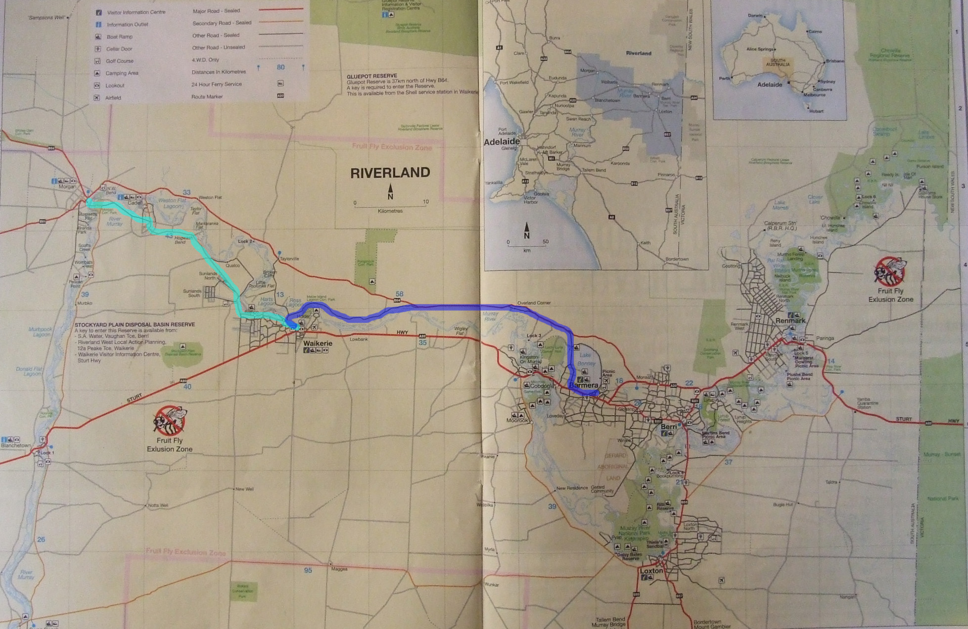
Callington to Blanchetown
or Morgan to Renmark