 |
 |
 |
|---|
| Next Page |
| Previous Page |
Wednesday 01 August 2007
As far as RV parks are concerned, the Wild Duck 3 km West of Terrace was one of the best we have stayed in so far. The price included showers (usually exta), power (usually not included), water, a table, a grassy site and no noise. We left camp later than usual because we wanted to stop at the shops and pick up a few supplies before we headed out of town. Having places so much closer these days means that we don't have to carry as much food and that sure takes some pain out of the hill climbs. Sitting in the carpark at the supermarket often means many locals often come and have a chat to find out who we are and what we are doing cycling and touring while they are working. One such visitor this morning was Merv Ritchie who arrived on his electric scooter. Merv runs an online newsaper (www.terracedaily.ca) in town and so interviewed us.
For some reason the traffic seemed in such a hurry this morning and leaving town we managed to get over the two bridges without being squashed or causing too much of a hassle in the traffic. Not far out of town however the local road workers were out filling the cracks in the road with liquid tar and then dumping loose gravel on the top and allowing the trucks and the traffic to pound it into place. The problem with that method is that being slow and not encased in a vehicle we often wear some of the loose gravel, especially when the traffic is so hell bent on getting past the roadworks as fast as it can. Calm and safety was restored about 2 kilometres later and as soon as we got out of the gravel it seemed like all the traffic disapeared.
Still following the Skeena River, the road was slightly more undulating than before, probably because the railway and the gentle grades that it runs on have gone in a different direction, we are however still able to see snow covered mountains and that sure helps take ones mind off of the hills.
Starting late meant that todays ride routine was all amuck and so it seemed that just after we started riding we  were stopping for lunch, todays stop being the picnic area at Kitselas Canyon Creek. The picnic area at the end of the campsites overlooked the rapids as the creek came pounding out of the canyon. Sitting at the table while enjoying lunch in the sunshinewas so pleasant that it was a shame to leave. Heading back out the 1.5km's to the road we came across some more wild rasberrys so stopped to pick and devour them.
More snow covered mountains came into view as we climbed yet another hill, stopping halfway up to photograph and enjoy the waterfall as it came down the mountain and disappeared under the road. Enjoying the downhill on the other side we levelled out along the riverbank and came to a nice rest area complete with toilets, tables, viewover the very fast flowing Skeena River and with snowcovered mountains behind. The absence of No Camping signs confirming that we could camp unhindered led us to select a spot next to the riverbank near a table and looking directly over the river at the snow covered montains.
Today's Stats
From: Terrace
To: Rest Area on Skeena River
Ride Time:
3 hrs 1 min's
Distance:
41.56 km's
Av Speed:
13.7 km/h
Max Speed:
45 km/h
Max
Altitude:
157 m
Av Climb: 2 %
Max Climb: 5 %
Weather:13-29 deg C. Sunny.
Camp Location:
N: 54:42'54.4"
W: 128:18'42.9
Thursday 02 August 2007
As is often the case, todays ride was a mixed bag. Having spent a peaceful night on the riverbank we awoke to find a semi-trailer and a campervan parked in the rest area. A dry night under the Western Cedar trees we packed up and commenced our day. The temperature was a cool 10 degrees Celcius and despite the fact that we were riding it was cool enough to have long pants and a lightweight jacket on.
The river continued to wind its way past us on the left handside and the mountains around us still had some snow  on them, albeit a small amount. Following the river meant that we were again working our way along between two ranges, the railway line was also following the river but on the other bank, why they separated the two I have not idea but as the railway always takes the easy grades at times we were wishing the two were still together. One of the best things about cycling is the ability to stop almost anywhere and take photos, something that cannot always be done when enjoying motorised transport, and that was the case today, we managed to stop on out of the way of traffic and right on the bridge where it crossed Big Oliver Creek, the water flowing down through the canyon on its way to the river about half a kilometre away was spectaular.
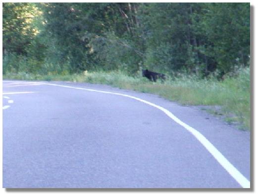
Plenty of wild rasberrys on the side of the road again today but for some reason we didn't stop to eat any. We were enjoying a smooth run and having a chat when suddenly there was a loud noise next to us followed by something rushing through the bush, both of us looked over and there was the a black bear heading for the safety of the treeline. Of course we were thrilled to have seen a black bear and even more thrilled that he had been going in the opposite direction to us.
Stopping for a beak overlooking the river we were wishing that the sun would rise high enough in the sky to shine on us and provide some warmth. A new sign appeared on the roadside today - Overtaking lane 2 km ahead, and that can only mean one thing- hills! Almost at the top of one hill Joanne calls back to me to stop, not a good thing on a hill, but she had spotted a bear on the side of the road some 100m ahead. It was there standing on its hind legs and trying to get something off of a tree, it then dropped down onto all fours and looked like it might cross the road, in the meantime we slowly pedalled closer hoping to get a better look yet stay a safe enough distance (whatever that is!) away. A couple of cars went past and the bear didn't even batter an eyelid, but then as we were getting slightly closer it must have sensed us, it stood on its hind legs to get a better smell of the air and then took off into the bush. Perhaps it recognised us as human beings and perhaps the fact that we both needed a shower mae it take off. Riding up to where it had been we began talking loudly and even used the airzound just to make sure the bear knew we were there, andso with one eye on the bush we continued riding.
Lunch was at a rest area that we had considered camping at, but for some reason neither of us felt the desire to stop there, so in keeping with our gut instinct, we finished out lunch and continued on, eventually arriving at the junction to the Cassier Highway, the very highway that we would have come down had we not taken the ferry down the inside passage. A sign informed that the highway was closed south of Dease Lake, the reason we found out later to be that the road had been washed away into the Skeena River caused by the runoff from the excess snow melt. 4 km later we were at the Kitwanga Campground where we took over the rotunda, enjoyed a long hot shower and set up camp, snapping the end on a tent pole in the process, so it was a good job that we had a pole repair kit.

There's a bear in there...
is that two cyclists I see coming up the hill?

Hello driver!
Today's Stats
From: Rest Area on Skeena River
To: Kitwanga
Ride Time:
4 hrs 59 min's
Distance:
65.76 km's
Av Speed:
13.10 km/h
Max Speed:
44 km/h
Max
Altitude:
295 m
Av Climb: 2 %
Max Climb: 10 %
Weather: 10-30 deg C. Sunny.
Camp Location:
N: 59:06'49.8"
W: 128:02'04.6"
Friday 03 August 2007
Drying out the tent after a heavy dew and packing up saw us ride the 4 kilometres back to Highway 16 -The Yellowhead Highway, named after an Indian with a yellow head, presumably blonde hair. Just before the highway we stopped to view the mountains known as the seven sisters, their high rocky peaks, some covered with snow, tall enough to be holding up the sky. We also stopped to look at St Pauls Anglican church with its very distinct bell tower which contains the original bell from 1893. Back on the highway the road again followed the river and there was more than a few hills to take our minds off the scenery.
Traffic was reasonably busy and a black bear chose its moment between vehicles to cross the road about 100m ahead of us and an attempt to get it on the helmet cam resulted in a black blob leaving the road and going into the bush. The bear was really the only item of significance today.
Arriving in New Hazelton we stopped at the Tourist Information Centre and picked up our food cache that Murray and Joyce had dropped for us on their return trip. It was almost as if the girls in the centre knew to expect us today as the very mention of their holding a parcel had them off to the storage cupbaord to retrive our box of goodies. Out in the carpark it was time to spead the tent and a few other things out to dry while we packed the trailer with the contents of our food cache and then it was time for lunch.
Lunch over we rode the 2 kilometres to the steel suspension bridge that has a metal lattice work deck allowing you to view the canyon and the Bulkley River below. The bridge is a one lane affair so the traffic coming the other way had to stop and wait for us to cross. From the bridge it was an undulating road to the original town of Hazelton andthe Ksan Indian Village and Campground. The town itself has been restored and is maintained in its original style as it was during the gold rush and was fun to ride around before we rode back to the campground and settled in, disappointed by the Wi-fi that didn't work and hadn't done so for a few days.
Joanne took a short walk to the Indian Village to see if she could get on a tour, but they were closed for the day so she just managed to get a few photos of the long houses and the totems.

Today's Stats
From: Kitwanga
To: Ksan Indian Village Campground, Hazelton
Ride Time:
4 hrs 40 min's
Distance:
60.18 km's
Av Speed:
12.8 km/h
Max Speed:
55.5
km/h
Max
Altitude:
397 m
Av Climb: 2 %
Max Climb: 9 %
Weather: 8-31 deg C. Sunny.
Camp Location:
N: 55:14'59.1"
W: 127:40'55.1"
Saturday 04 August 2007
Being a Saturday the traffic today was light. Just before we left the campground we learned that Pat and Ralph might be in or around Smithers some 70 km ahead of us, and we wondered if we might meet them again. Climbing back up the hill before stopping for a walk and closer look over the metal decked suspension bridge we eventually arrived back at the highway and the long 5 kilometre climb out of town.
Leaving late because we slept in and then cooked oats for breakfast meant that our normal daily ride routine was well out of wack and rather than just going with the flow we found ourselves fighting with the day to try and regain the "status quo", but it never happened. Everywhere we look there are mountains, big and imposing, their sides covered with green trees and their tops often covered with snow. Each corner we turn seems to find another set of mountains to look at and of course the road wants to climb.
Stopping for lunch we saw two cyclists approaching and as they got level with us they stopped for a chat. On their way to Prince Rupert to catch the ferry back to the island they live on near Juneau, they were riding Bike Friday's and apart from the usual camping and touring gear, they were towing a 2 year old dog in a plastic dog kennel. They had modified the suitcase and wheels that the the bike goes in for transportation to put the kennel on and it was an interesting set up.
Lunch over and the dog towing couple on their way we continued on and eventually arrived at Moricetown where after scooting down a hill we witnessed with nets on long poles fishing for salmon as the water rushed through the Moricetown Canyon. While we were watching the fishing and wondering ifwe shouldride on or not we met a cyclist out for a short 30km ride from Smithers. Paul was very friendly and informative about what lay ahead for us and we enjoyed our chat with him. With more than 30 km to Smithers and with flagging riding spirits we rode over the bridge and up the hill to the campground where for $12 (+ tax) we picked a nice campsite, had a shower and did some washing.

Moricetown Canyon

Salmon Fishing (scoop net on end of pole)
Today's Stats
From: Ksan Indian Village Campground, Hazelton
To: Moricetown
Ride Time:
3 hrs 52 min's
Distance:
45.83 km's
Av Speed:
11.8 km/h
Max Speed:
61.0 km/h
Max
Altitude:
475 m
Av Climb: 3 %
Max Climb: 9 %
Weather: 10-29 deg C. Sunny.
Camp Location:
N: 55:00.51.0"
W: 127:19'23.1"
Sunday 05 August 2007
Waking to a foggy morning we left our campsite and nit the highway, but not until we had stopped to take a few photo's and witness the local indians using their nets and poles to catch salmon in the fast flowing canyon. Leaving Moricetown we rode past a sign that disturbed us a little, it was telling girls not to hitch hike on the "highway of tears" as there had been three young women become victims to a killer that was still on the loose. We wondered how old the sign was but thought about how easy it would be to become prey to some individual if you were hitch hiking onyour own, and at night.
The road and scenery was pretty much the same as the last few days, mountains all around with trees up to a certain leveland then hard rock faces, some covered or partly covered with snow, just the thing to take our minds off of the hills. Cresting a hill about 5 km out of Moricetown we began a descent and just as I was at a good speed I spotted a large black bear sitting about 15 feet from where I passed, quickly pointing it out to Joanne who was some 50m or so behind me I began to brake so as to be ready to assist Joanne as she came past. Joanne had seen the bear about the same time as I did and as she was far enough behind me had stopped before she arrived anywhere near it. With both of us reaching for our camera's the bear decided it didn't want its picture taken bytwo cyclists and took off into the bush. Joanne came down to where I was and we both began excitedly chatting about the bear, which we then heard as it crashed through the bush as it escaped from our location.
Excitement over we continued on, up hill, down dale and heading towards Smithers, eagerly scanning the sides of the road for more bears. Just before we arrived in Smithers we passed the Hudson Glacier on Hudson Bay Mountain.

Hudson Glacier
Smithers was like any other large town on a Sunday, its main shopping area a pretty place and quite pleasant on the eye but closed and quiet, just right for cycling through and window shopping. Cycling over to the supermarket Joanne shopped for a few things while I guarded the trikes and entertained anyone who wanted to chat about our trip. As it was lunchtime Joanne bought us some nice fresh rolls and a cold chocolate milk from the supermarket so we sat in the carpark and ate them. Just as we were leaving who should turn up but Paul, the cyclist we met yesterday at Moricetown.
Leaving Smithers resupplied and with full bellys we rode off towards Telkwa where we had hoped to get a campground with Wi-fi, but on arrival found a town that must suffer from Smithers being just down the road. Most of the businesses there seemed to be closed down and many of the buildings for sale, so we rode on. Fort Telkwa RV park was a no tent park so we rode on some more. With the sun starting to heat the place up to a sultry 29 deg C we climbed out of Telkwa and eventually found a nice private campground with nice camping spots right on the river (still no Wi-fi, but plans to put it in), and so ended todays ride.
Today's Stats
From: Moricetown
To: 6 km East of Telkwa
Ride Time:
4 hrs 20 min's
Distance:
55.70 km's
Av Speed:
12.8 km/h
Max Speed:
49.5
km/h
Max
Altitude:
626 m
Av Climb: 2 %
Max Climb: 10 %
Weather: 10-29 deg C. Sunny.
Camp Location:
N: 54:39'52.8"
W: 126:59'40.1"