 |
 |
|---|
| Next Page |
| Previous Page |
Monday 07 January 2008
Yesterdays bad weather had made its way across the state and this morning the sky was looking rather ominous, the 40 kilometre trip to Tombstone was going to be an interesting and windy one. The road surface was a good one, smooth and importantly, bumpless. Riding out of town we could see the mountains around us and the clouds that were hanging around them. The wind was blowing quite well and was definitely going to be a hurdle today, tumbleweed larger than our trikes blowing across the road.
Riding through the area where homes were on acreage seemed to make the town run forever, the wind continuing to chill us to the bone and make riding hard. Passing a US Border Patrol vehicle we arrived in and rode through the small town of St David where many of the homes had pecan trees in their yards. The wind had picked up and was slowing us down to single digit speed, so a stop out of the wind near the local cemetery enabled us to rest and to grab a bite to eat.
The terrain changed some what and turned into what can only be described as diggings, the road climbing up and through cuttings and small ranges made up of what seemed to be piles of dirt, the lee of the cuttings allowing us to rest for a few feet and then the wind belting us as we came out of it.
Tombstone loomed up ahead, the road taking us up and up and the closer we came to the middle of town the more the place resembled a western movie set and somewhere we wanted to explore some more - tomorrow.

Today's Stats
From: Benson
To: Tombstone
Ride Time:
3 hours 46 minutes
Distance:
42.24 km's
Av Speed:
11.2 km/h
Max Speed:
35.5 km/h
Max
Altitude:
1390 m
Av Climb: 2 %
Max Climb: 9 %
Weather: 7 -13 deg C.
Camp Location:
N: 31°42'50.0"
W: 110°03'57.4"
Tuesday 8 January 2008
After enjoying a sleep in and leisurely morning we headed downtown to inspect Tombstone and to visit and learn some of its history. The town's motto is that it is a town that refused to die even if its famous inhabitants did, and there if no doubt that the only reason it is here is it's past, most notably the gunfight at the OK Corral and the exploits of Wyatt Earp and Doc Holiday.
It seemed funny to see the modern day transport of the Marshall parked outside of gates adorned with a sign informing of the location of the gunfight location, and a walk back from the main street was almost like a walk back into the 1880's-except for the tourist memorabilia and jewellery stores that seemed everywhere.

The main shopping street, where vehicles are banned is a tourist trap, the sidewalk is wooden, the shops, like the people are in character, and some are adorned with plaques attesting to their previous use and location authenticity, but that is where the originality stops, and in fact this focus on tourism almost lost the town its designation as a National Historic Landmark District.


Various signs around the place inform of who was shot by whom and on what day, there is a comical re-creation of the gun fight at 11.30 am and then a serious, more factual recreation on the original site at 2 pm, and of course there are various other places to visit such as the Bird Cage Theatre.
The Bird Cage served as a theatre, saloon, bordello and gambling hall, and is where a poker game allegedly went for 8 years! The period costumed man with the somewhat fake accent in the front, informing all of the history of the building, showing off its in situ bird cages connected by a catwalk, stairs where the famous and infamous walked up to visit the ladies, the history of the cherry wood bar, and of course bullet holes in various parts of the interior, and for those who wanted more, there was a $10 tour of the rest of the building.

So while there were some historical things to see - such as the courthouse and plaque adorned buildings, most of the place is a preserved or recreated location of the original 1880's the focus now is getting your money through selling you your genuine imitation souvenir; sheriff's badge; cowboy belt buckle; antique cowboy pistol; cowboy or indian costume; gaudy rattlesnake mugs, jugs and paperweights, and which detracts from the real history of the town, making the experience somewhat disappointing.
Some more information on the town can be found here.
Tombstone AZ
Wednesday 9 January 2008
Tombstone was still asleep when we left this morning and despite the cool morning we were getting warmed up  by climbing out of town for around 5 kilometres. The hills around the town were fairly bare, with only small bushes on them and there was not much to look at.
Reaching the top we could see the road as it crossed the fog covered plain laid out ahead of us, and yet another range behind that, but we were more interested in the downhill.
Heading down was great except that the sweat I had raised climbing was now cooling as we descended and was giving me a headache similar to one caused by eating ice cream too quick, but not wanting to slow down and spoil the downhill run it was a case of putting up with the pain for a few minutes - ouch!
Ahead of us was a range of hills that would test us and make us work pretty darned hard for around 10 miles, up and up we went, slowly clawing our way up the 4-5% gradient, riding on the side and in amongst the gravel and road debris with many stops to rest the legs and lungs.
The view as we rode up the range 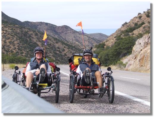 was a pleasant one, the light brown rock covered with small green trees was making for a pleasant view, and the sun was adding to the heat we were generating as we climbed and stopping for a rest meant that the cool wind chilled our perspiration and chilled us to the point that we wanted to get going again to warm up.
Stopping near the top we took some photo's and even managed to get a photo of ourselves as we rested.
We were so glad to reach the top of mule pass and the sign informing us that there was a 5 mile downhill really made us smile.
Over the top we went and as we began the descent we passed through a short tunnel, popping out the other side at speed as we hurtled down the hill towards the town of Bisbee sitting in the canyon, its colourful period buildings enough to get us to test our brakes and stop for a look at the view. Because the town is sitting in a canyon the streets are very tight and narrow and so riding through them for a look at the place was an interesting experience, the drivers all very patient as we made our way slowly through the town. Accommodation around town is in restored buildings and the price is expensive, but 5 kilometres out of town the price is better, so seeing that camping is impossible around here, the RV parks are no good for tents and free camping impossible because of so much private property, we were again in a motel for the night.
Today's Stats
From: Tombstone
To: Bisbee
Ride Time:
4 hours 00 minutes
Distance:
48.53 km's
Av Speed:
12.1 km/h
Max Speed:
69.5 km/h
Max
Altitude:
1811 m
Av Climb: 3 %
Max Climb: 11 %
Weather: 7 -15 deg C.
Sunny.
Camp Location:
N: 31°23'45.2"
W: 109°55'53.0"
Thursday 10 January 2008
Bisbee was rather cool this morning and with a negative temperature start to the day we were glad of the short 5 kilometre climb back to the highway. Passing through one of the few roundabouts we have found here in the US, we began heading out of town, passing more mining and then out through a small canyon, and all with a downhill bias. Out through the canyon and down onto another plain we could see mountains ahead filling the horizon and the (non visible) border with Mexico not far from us.

Once out of the canyon area we were into relatively flat country which made the riding easy. Plenty of Police from Bisbee and Douglas on the road along with Cochise County Sheriffs', US Border Patrol and Customs as they patrolled the road that runs very close to Mexico.
Arriving in the border town of Douglas we stopped at the visitor information centre before doing some food shopping and paying a visit to the US/Mexico border to see if we could get an immigration question answered. The border was very busy with traffic and people walking back into the US before we took a ride past the border fence, housing in Mexico visible and right up to the fence. It was then time to ride through the old business part of town, many of the businesses looking like they had seen better days, many with Spanish as well as English on their signs, and then it was time to find a cheap and cheerful motel for the night.
Today's Stats
From: Bisbee
To: Douglas
Ride Time:
2 hours 51 minutes
Distance:
49.48 km's
Av Speed:
17.3 km/h
Max Speed:
44.5 km/h
Max
Altitude:
1572 m
Av Climb: 2 %
Max Climb: 7 %
Weather: 3-20 deg C.
Sunny.
Camp Location:
N: 31°21'14.5"
W: 109°32'43.3"
Friday 11 January 2008
Loaded up with food and water for our 145 mile journey to Columbus we left Douglas and began the 10 km long slow climb up the range. The sparse the Perillo mountain range ahead of us there for us to enjoy as we rode slowly up the hill, our legs straining against the load and gravity. Traffic was exceptionally light today meaning that we had the whole place to ourselves more often than not - not that we were complaining.
Reaching the top of the range we rode across through a small canyon and range before dropping down slightly and heading out into the San Fernando Valley. The scenery here was just wonderful, the tall, steep and light brown mountain range with its distinctive buttress wall along the top was majestic, and with the plain laid out before us the silence was deafening - it was a really great moment to be riding through there. Such beautiful scenery got the creative juices flowing and so it became movie time! With the beautiful range behind us for a back drop, we set up the camera on the road and then on the tripod, allowing us to ride past a number of times to get some nice movie footage. Click here for Movie # 1 and here for Movie # 2. (They should play on windows movie player)

Riding on and into the San Simeon Valley we were heading further and further into Apache country, passing spots  on the map such as Bernadino and Chiricahau, but in reality there was nothing there. Some spots did look like the set of a western movie and it was easy to imagine the Indians yipping and hollering as they rode down the hill or across the plain to attack the helpless wagon train - but not today.
Approaching Apache we were careful not to blink as we passed because even pedaling past on a trike we would have missed the three houses that made up town.
Just past town we stopped at the Geronimo Surrender Monument, testament to the last Apache Indian Chieftain to surrender to the US Army. His surrender took place on September 6 1886 in Skeleton Canyon, just a short distance from this spot, and at the base of the range that we were looking at as we sat under the roof at the picnic table, and which would soon will become our campsite.
Today's Stats
From: Douglas
To: Apache
Ride Time:
4 hours 6 minutes
Distance:
63.20 km's
Av Speed:
15.4 km/h
Max Speed:
39.5 km/h
Max
Altitude:
1411 m
Av Climb: 1 %
Max Climb: 9 %
Weather: 3-24 deg C.
Sunny.
Camp Location:
N: 31°41'44.2"
W: 109°07'44.6"
Saturday 12 January 2008
Camping last night in the front yard of the Apache Chief Geronimo was very pleasant, the coyotes were yipping and howling throughout the night and once we got past the bumps in the night and other strange noises that spooked us we settled into a nice sleep. Aa nature call during the night forced us to get up out of the warm tent but then showed us just how magnificent the sky is around here, the cool of the night spoiling the viewing and quickly sending us back into the tent to warmer conditions.
Waking this morning and getting up just before the sun came up over the mountains saw us trying to unlock a frozen brake and getting the ice off the tent before we could get going. Eventually, with us and our equipment thawed out we began the days ride with the temperature still in negative numbers, and the cool of the morning fresh against our exposed skin.
We had gone no more than a few kilometres when the back wheel of Pip began to deflate and me wonder why Joanne was able to pull away from me, something she rarely does, and then that horrible squishy feeling underneath me confirmed what we I suspected, a flat tyre. Stopping to repair the problem and removing the almost inch long thorn that had found its way past the Schwalbe tyre protection, and the thorn proof inner tube we packed up and continued on our way, crossing the Arizona/New Mexico State Line in the process.

Stopping for the obligatory photo we rode on and arrived in the very small town of Rodeo, another town that had obviously seen better days and that was just clinging to life. Leaving town we managed see a road runner bird (yes, they do exist) as it ran across the road in front of us, and then, as we got a few more kilometres down the road that old familiar squishy feeling came back, another flat tyre on the rear courtesy of a hole I had obviously missed the first time around.
The road in New Mexico had deteriorated quite a bit and although there was a shoulder to ride on, the grass was quickly taking it back and making riding very uncomfortable, so with exceptionally light traffic, we just rode on the road until we turned off onto SR9, the state road that would lead us to Animas.
Climbing up the range we were passing through open range country with nothing but sand and creosote bush no higher than about 3 feet. The road surface had improved and the view of the range was just great, the sandy colours mixed with pinks and other shades depending on the angle of the sun to the rock face and topped with one of the bluest skies you could ever see. Up and up we rode, our legs straining against the load and gravity, our eyes peeled for that crest that would signal the end to the struggle.

New Mexico Flag
Eventually arriving at the crest we then began a 12 kilometre approach to Animas through the open grassland where you wonder at what there would be for cattle to eat amongst the yellow, lifeless looking grass. Large brown volcanic looking rocks strewn across the paddock like smarties spilt across the floor, and with fences right up to the road, camping along here was not an option either.
Riding into Animas where our research had told us was a store, was a little bit concerning. The outskirts of the locality more like a junk yard and certainly no sign of a store, let alone anywhere to get the water that we would need for the trip ahead. Arriving at a "T" intersection we saw a sign informing of a store and groceries 1 mile ahead, but with no signs telling which way was ahead we chanced our luck on some buildings that looked like some sort of commercial hub, arriving to find the cafe closed and a man watering the plants at the Post Office.
Our man with the hose told us that there was a campground at the store and then showed us which road to take to get there. And so, a mile later, we turned up at Linda's Store, in the middle of nowhere. No showers or toilet in the campground (pick a bush) but for $5 we could camp there, water for free. Grabbing a cold drink we rode on out the back and selected a nice spot right as far awayfrom anyone aswe could, and with some privacy bushes nearby and set up camp next to the bed of a disused railway line.
The man at the Post Office came home to his trailer and came over for a chat. John has lived there since 2001 and we had an interesting conversation about all sorts of things before he left us to our devices, one of which was trying to cook on our stove which had decided to break again. Finishing our meal as the sun went down and the temperature began to plummet, we packed up as quick as we could and made a bee line for the tent.
Today's Stats
From: Apache
To: Animas NM
Ride Time:
3 hours 26 minutes
Distance:
52.05 km's
Av Speed:
15.1 km/h
Max Speed:
26.5 km/h
Max
Altitude:
1356 m
Av Climb: 1 %
Max Climb: 5 %
Weather: -3-21 deg C.
Sunny.
Camp Location:
N: 31°57'01.1"
W: 108°47'48.7"
Sunday 13 January 2007
Last night was a reasonably quiet night despite some dogs nearby barking continually until around midnight and we awoke to another -3 deg C morning, complete with frozen brake cables and water bottles. Hoping that the sun would warm things a little and defrost the tent, we stayed in bed for an extra 30 minutes, only to get up and find the sky full of cloud! Packing up we enjoyed breakfast while chatting with John and then it was time to climb out of town and be on or way.
We began our climb up to Continental Divide into a cold headwind, and a wind that would remain a headwind for  the rest of the day. Stopping at the Continental Divide (4,720 feet) for a photo and small movie shoot, we then began heading down towards the Playas Valley, allegedly home to the US Army's Iraq training ground, the road long and straight just like in the movie Forest Gump.
Leaving the valley we began yet another climb, this time up to near where the Continental Divide winds its way through the countryside. Desert all the way with nothing but sand and creosote bush, mountains (some with snow) falling behind us and smaller ones with names like "Little Hatchet Mountain" before us, the tops of them eroded to look like they had had a mohawk haircut.
Eventually reaching and passing through Hatchita (silent H) we observed a town in ruin, none of the businesses were open and most things were either overgrown or for sale. Leaving town we were again heading uphill, passing some more Border Patrol personnel in their distinctive white with green stripe patrol and detention vehicles. Standing there talking in their green uniforms, belts full of weapons, sprays, batons and probably a kitchen sink if you looked hard enough, they waved to us as we rode past. Their patrol includes running along the fence line between the road and the bush, looking for footprints and signs of people on the move. People and drug smuggling from Mexico is a rampant business and obviously one that will keep them on their toes for quite some time.
Riding on and with our Border Patrol friends in mind, we eventually found a campsite down a County road inside one fence and cattle grid and outside of another fence and cattle grid, a sort of no mans land on the opposite side of the highway and patrol line, and once again right next to the old railway bed that used to carry the trains full of copper from Bisbee to El Paso.
Today's Stats
From: Animas NM
To: Bush Camp 8km S Hachita
Ride Time:
4 hours 38 minutes
Distance:
58.9 km's
Av Speed:
12.7 km/h
Max Speed:
26.2 km/h
Max
Altitude:
1448 m
Av Climb: 1 %
Max Climb: 6 %
Weather: -3-20 deg C.
Sunny.
Camp Location:
N: 31°52'52.7"
W: 108°12'36.0"