 |
 |
|
|---|
| Next Page |
| Previous Page |
Monday 11 June 2007
Leaving our rest day camp, we rode off towards Atigan Pass under clear blue skies, a coolish tailwind and around 11 deg C, a perfect day for a climb, but little did we know how perfect the day would become.
Riding out onto the road we were immediately heading up hill, the road was rough and like riding on cobble stones, sapping our energy and making us wonder how we would cope if it continued like this the whole way. The road surface was working against us as was gravity, the view however was fabulous, the surrounding mountains with their various shades, shadows being cast where the surface was away from the sun's touch and the occasional bit of snow clinging onto an ever shortening life. Distances are very decieving up here and a simple view of the road ahead is often punctured when a vehicle comes into view giving one's eye and mind a proper perspective.
After about an hour we finally came to the bottom corner and the sign that told us we were at Atigan Pass. 
Looking up allowed us to see where we were about to go and the odd vehicle coming down sure gave us some perspective of the task ahead. We began the climb, passing through avalanche lines and maintaining an incredible speed of between 3 and 4 kilometres an hour, stopping every 50-100m to rest our legs and knees, which were screaming at us to stop, the ever changing view providing us with something to take our minds off of the pain. Slowly but surely we climbed, the valley and road below becoming smaller and smaller, the gravel giving way under our rear wheel causing us to expend energy for no tangible reward.
Parts of the roadside were still covered in thick ice, the cold air around it still able to be felt if we went close enough, and thoughts of cuddling up to it to cool down came to mind.
We reached what we considered to be the halfway mark and took a rest, enjoying some dried fruit and large gulps of water, cooled naturally by the fresh mountain air and the mountain stream that it had come from. Refuelled and slightly rested we began the final climb, thoughts of this being like  climbing Everest, inch by inch, one foot after the other and with lungs bursting, for what seemed like an eternity. A look over the guard rail, which looked like it had done its job a number of times, showed the road we had ascended and of course where the pipeline was buried. Pumping crude oil up this mountain must take an enormous amount of energy- just like riding it.
After over an hour on the job we hit the top and with not so much as a stop for a look, we began the descent in earnest, brakes on almost the whole way. We were being pounded by the gravel and corrugations, our eyes diverting from the road and task at hand every now and then for the briefest of seconds to soak up some of the fabulous view. Descending was shorter and steeper, not to mention quicker, than the ascent side, but the view either way was superb. Stopping a few times to allow the brakes to cool gave us the opportunity to take some pictures and to view the road far down below in the valley. A few more stops and we were down, looking back up at the road and thanking our lucky stars we were not about to climb back up. We had reached and conqured a huge mile stone in our trip and we were silently elated.
The road from the bottom of the south side of the pass continued with a downhill bias and the gravel  surface of the road improved, smooth and fast we bagan to make real good time, our average speed over the pass was 4.7 km/h, and within a short while it had risen to over 11 km/h - woohoo!
We passed Chandalar Dept of Transport Station then stopped for lunch at a turnout overlooking mountains and a lake. Just as we were leaving two vehicles pulled up, the occupants all getting out to stretch their legs, the leader, a teacher came to talk to us. They were all from California and on a Biology trip. When asked where we were headed we said Calgary, the teacher then asked us - "where is that?" Totally gob-smacked I replied - Canada, before she changed the subject and then went back to her class leaving me shaking my head.
Immedaitely after we left the rest area we bagan another long, steep and very slippery descent - Chandalar Shelf, along 10-12% graded hill  which physically denotes the change from Arctic Tundra to Boreal landscape. Arriving at the bottom of the two mile long drop we were on another planet. Gone was the arctic tundra with it's grassy, wind swept treeless plain, we were suddenly amongst taller shrubbery and even trees - spruce trees, the northern most of which is sign posted, but has been ring barked by some person of questionable intellect. Moving on there were more trees, shrubs, soil and grass, a total change from what we had been riding though for the past 8 days, and it was not only the landscape that changed, our riding speed again increased and our demeanour brightened by the kilometre.
Bright red flowered bushes called fireweed with a nice sweet fragrant smell lined the roadside as we rode along, providing us with another dimension of beauty for the senses, tall mountains on both sides of the valley where the river, road and of course, pipeline were also passing.
Stopping for a break near the river we saw a familiar vehicle approach, slow down, stop and reverse back. It was Donnie from Sag River Dept of Transport. Donnie was on his way home to Fairbanks and he came loaded with goodies - iced tea for Joanne and beer for me. We spent about an hour talking before he headed off leaving us to pack up and head off in search of a campsite.
Stopping about 5 kilometres from our eventual campsite, we cooked our evening meal next to a creek in the shaddow of Snowden Mountain, an impressive mountain that was allegedly carved by a glacier. Stopping to cook and eat before camping allows us to leave food and cooking smells behind and well away from our campsite, it also allows any food or cooking smells on us to disipate, that way we do not attract bears to our camp and can enjoy a peaceful night.
The mosquito's, or bugs, as they are more affectionately known up here, are definately around and there is no escaping them, they are however fairly slow and easy to kill, but the fact that there are so many of them makes life interesting. Going to toilet is such a happy event up here, people have been known to walk off into the bush singing and clapping as they go to select their spot, and on top of that needing to undress to relieve oneself has become a two person job. One to do the business and the other to fan the exposed area to keep it from becoming totally covered in itchy bite marks that later on would have one hoping around and scratching like a rabit dog. And all of this just to be able to keep the bears and bugs away.
Finding a gravel track down to the pipeline we set up our camp, hoisted our food up to the top rail on a metal archway over the road to stop the bears getting at it and before we knew it we were in bed resting after one very large and eventful day.
Today's Stats
From: Firehouse Camp at old Construction Site.
To: Base of Snowden Mountain
Ride Time:
5 hrs 6 mins
Distance:
58.82 km's
Av Speed:
11.50 km/h
Max Speed:
47.50 km/h
Max
Altitude:
1158
m
Av Climb: 4 %
Max Climb: 15 %
Weather: Sunny 11-24 deg C
Camp Location:
N: 67:45'08.2
W: 149:45'50.7
Tuesday 12 June 2007
Our campsite was a very peaceful one and we slept quite well, the proximity of the road and the occasional vehicle didn't bother us at all. We are less than 60 kilometres from Coldfoot and looking forward to meeting civilisation once again, though experience has shown us that we will get back amongst it again and be looking to get out of it just as quick.
The road was again undulating but the downhills allowed us to rest a little. The road surface was still smooth and allowing us to make good time. We were passing through ranges on both sides and the Koyukuk River and pipeline were paralell to the road. Further down the road we came to a river, still choked with ice, an ice shelf forming over the top of the water flowing underneath it and providing a unique view of the river.

Pleasant scenery and legs that were healing enabled us to enjoy the ride more and before we knew it we had covered 20 kilometres. Finding an outhouse in a turnout next to the Koyukuk River, we decided that it would make a great place for morning tea, that was until we saw the tell tale signs of bear activity - fresh bear scat (poo) and a definate track into the bush. We hightailed it out of there checking the bush on both sides of the road just in case. In fact, we have not been as paranoid about bears as we thought, but at times it seems like there is a set of eyes watching us from behind every bush or tree. We are getting more and more comfortable with the idea of bears being around as time goes on, and as our experience grows, with gut instinct and following the accepted rules and practices still our best weapon.
Stopping a little later at a turnout, we finally enjoyed our morning tea and looking up saw some sort of critter 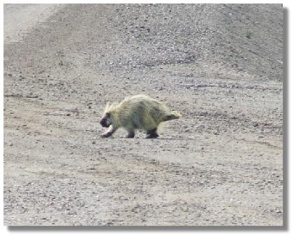 cross the road. Checking through the camera we managed to confirm that it was not a bear cub- but what was it? Checking later at Coldfoot it appears that it was an Alakan porcupine.
Edging ever closer to Coldfoot we approached the two bridges of the Middle Fork of the Kuyukuk and Hammond Rivers when in conjunction with a truck coming the other way, Joanne spots a blonde bear about 50m off the side of the road and coming our way. Just as she pointed it out, the truck came closer and we had just enough time to watch the bear stop, look at us and the take off back into the bush before the truck passed us. Looking back after the truck had passed the bear was nowhere to be found. We are not sure if it was the truck, us, or a combination of both that scared the bear away, but we were both excited about seeing one in its natural environment and both wishing that we had managed to get a photo. Neither of us knewwhat our reaction wouldbe to our first bear encounter, but as it turned out it was okay. We were going to stop and have lunch near the river but decided to put a little distance between us and that bear before we ate. When we did eventually stop for lunch we parked our trikes facing in opposite directions so that we could sit and eat and we could both watch out in either direction.
Lunch over and not shared with any wildlife, we continued on, by passing the small, old gold mining town of Wiseman 3 miles off the road in favor of getting into Coldfoot at a reasonable time, a descision in time we are are sure we will regret, but a the desicsion was taken anyway.
With a rain storm chasing us and a headwind slowing our progress we put the pedal to the metal and worked hard at getting to Coldfoot before the rain. Arriving in town we found it to be a small place (population 15) with a truck stop cafe, and old 52 room pipeline/road crew camp, now the Slate Creek Inn, a few other buildings, and tourist information centre back out on the highway.
Enquiring about a room we found that the Inn was full (literally) with tourists from the busses that were taking people on "the ultimate road trip" to Deadhorse . We collected our food parcel that Murray and Joyce had dropped off for us, before heading back to the tent just as the rain began to fall. Camping for free out the back near the dam, we arranged a shower ($10 each) before enjoying a huge buffet style dinner of lasagna, vegetables, salad, sweets and soft drinks. Clean, fed and more comfortable, we wandered back to the tent and settled in for the night, falling asleep while the sled dogs out the back howled at the sun (no moon to howl at).
Today is our eldest daughter's 30th, and her youngest son's 3rd birthday. Happy Birthday Dianne and Jarrod.
Today's Stats
From: Base of Snowden Mountain
To: Coldfoot
Ride Time:
5 hrs 39 mins
Distance:
68.82 km's
Av Speed:
12.10 km/h
Max Speed:
39.50 km/h
Max
Altitude:
591 m
Av Climb: 2 %
Max Climb: 10 %
Weather: Sunny 11-24 deg C then rain at Coldfoot
Camp Location:
N: 67:15'21.9
W: 150:11'14.9
Wednesday 13 June 2007
We awoke to rain falling and many tasks ahead of us. Taking a day off, we packed our food parcel and headed over to the cafe where we enjoyed a bottomless cup of coffee ($1.95) time in the warm, power to type up the journal on the laptop, laundry and pleasant chats with the staff.
This afternoon was taken up with a visit to the interpretive visitor centre, the odd chore around camp and some rest for the legs. Hopefully the weather (which has fined up) will continue, drying not only the tent but the road ready for us tomorrow. Unfortunately there are no Internet facilities in Coldfoot so the website was not uloaded.
Rest Day
Thursday 14 June 2007
The rain continued overnight but cleared enough for us to pack up and get underway. Coldfoot was full of semi-trailers and the day was starting for most people. Riding out of town through the slush and mud we commenced climbing almost immediately, but thankful for the sealed road and wondering how far it would go.
Uphill and down dale, we rode along enjoying the sealed road and were following the pipeline, visible for many kilometres ahead and always a good reference as to where the road was going to go, though sometimes we wished we had not seen it.
We were riding in between two ranges, the road often taking a side to side route making us work hard on the  climbs and relax and thrill seek on the downhills, one of which saw todays maximum speed of 70 km/h achieved.
The size of the hills not able to be shown very well except when a truck is on the road like in the bottom right of the photo here.
The sealed road continued on and were were making good time., the scenery that of the boreal forest of spruce trees, the occasional poplar, small meadows of grass and lakes where one would expect to find a moose feeding, but to our disappointment, none were seen.
After 40 kilometres we arrived at Greyling Lake, an important area in the past for the local indigineous people. Stopping for lunch and water we were immediately inundated with bugs (mosquito's) causing us to prepare and eat lunch wearing our rain coat, trousers, mosquito headnet and gloves - not such an easy task as it is almost a case of protection from the bugs or eat, but not both together. Talking with some motorists and then a motorcyclist we finished our meal as we have begun doing up here- quickly, not savouring the taste, just getting it in the mouth and down the gullet so as to get the job done and away from the bugs. Whatever they say about the bugs here in Alaska, you need to add another 50% to the amount in any tale to get the right picture, they are numerous and hungry.
Riding on and enjoying more sealed road, we passed Pump Station 5 and then came to Prospect Creek, the area where the lowest recorded temperature in the USA was taken - 62 deg F or -80 deg C. Thankfully the temperature was nowhere near that today! Deciding that we had had enough, we found a nice gravel road down to the pipleline and set up camp in an open area near some piles of gravel, not the most beatuiful spot we have camped in but it is safe and clear around us.
Cooking our meal away from our tent area we were joined by a couple we met yesterday at Coldfoot - Ralph and Pat. They are on their way from Deadhorse all the way to the bottom of South America on their bicycles. After a quick chat, Ralph and Pat left to get away from the bugs and to cover the remaining 20 miles to the Arctic Circle, leaving us to get on with our meal before the rain set in. All in al it was a good day today but the bugs are really starting to bug us.
Today's Stats
From: Coldfoot
To: Prospect Creek
Ride Time:
5 hrs 27 mins
Distance:
66.3 km's
Av Speed:
12.1 km/h
Max Speed:
70.0 km/h
Max
Altitude:
483 m
Av Climb: 3 %
Max Climb: 13 %
Weather: Sunny 11-19 deg C then rain at camp
Camp Location:
N: 66:46'38.4
W: 150:41'06.4
Friday 15 June 2007
After a pleasant, trouble free night we awoke to clear skies and more hill climbs, starting with a 2 mile (3.2km) 12% climb up to the top of Gobblers Knob. The continuous climbing causing us to stop on a regular basis to rest the legs and the lungs. Eventually reaching the top we were rewarded with bear proof litter barrels, an outhouse and a great view of where we had just climbed from. Little in the way of vegetation, lots of dead trees courtesy of the spruce beattle that is eating them all and a cool wind.
The climb to the top of Gobblers knob over we descended like a bullet out of a gun over the next 2 miles (3.2km), reaching break neck speeds over 70 km/h, Joanne topping the list at 74.5km/h. It had taken us over an hour to climb to the top and less than 10 minutes to get down. Passing through heavily wooded areas we came to a creek where we found Ralph and Pat drying out their gear after they had got caught in the rain that we managed to miss. It was great to have a chat with them, comparing gear and ideas, before filtering some water and heading off, they still in the throws of putting it all back together again.
We were heading up hill again, Connection Rock being near the top, a plaque bearing witness to the connection, but of what? We presume part of the road. Climbing to the top we were again rewarded with more views of the road and valleys ahead. This was going to be a tough days ride.
Before long, and after climbing yet another hill, we were scooting down the other side and dodging huge pot holes large enough to lose us in when one of my panniers decided to unhook itself and act like an anchor as it was dragged down the road at over 60 km/h, causing a fair bit of damage to the outside of the pannier but luckily not to any of the contents. I told Joanne that it was her sabotage to ensure that I didn't beat her 74.5 km/h top speed and that made her laugh and I think she is silently happy about beeating me at the speed game.
Climbing another small hill we arrived at the Arctic Circle, the imaginary line around the world 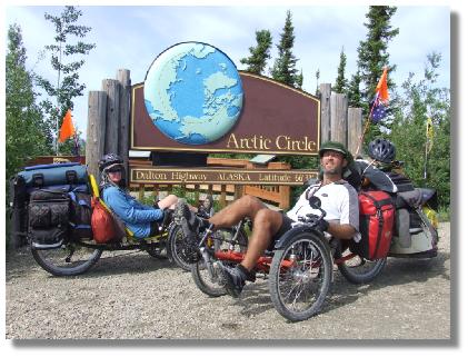 at 66 degrees, 33 minutes North. We stopped to take pictures and video with Ralph and Pat before we were inundated with people (Aussies) who had driven up from Fairbanks and were on their way to Coldfoot before flying out. Questions and Answers time over we left the nice tree lined area complete with toilets, tables and chairs to seek the protection of the wind from the mozzies, down on the side of the road being the best place.
Lunch was with Ralph and Pat before they headed off down the road, the wind keeping the bugs at bay and allowing us to eat in peace.
Setting off again we descended a fair way before the Beaver Slide Hill came into view. The Beaver is a 2 mile long 12% grad hill that was going to test our metal, and on top of that the road was all chopped up on the steepest bit because they were doing roadworks. Grinding our way up to the roadworks, stopping every 50 metres or so for a rest and looking at the job ahead was soul destroying.
We hit the mud and began to climb at a mere 2-3 km/h, the mudguards on the front wheels clogging up and looking like astrange sausange making maching as the mud accumulated and then fell out the sides and bottom to the road.. This hill was going to take at least an hours worth of very  hard slog to get to the top.
And then it happened, the man driving the compactor stopped and asked us if we had a rope, to which I replied "yes". Our newest best friend - John Sour, offered to tow us to the top through the mud because in his words, "it is real mushy further up". We agreed and when he came back up on his other run up, we attached our rope to his machine and enjoyed a tow up the hill, much to the amusement of some other motorists as they came down.
Once at the top we enjoyed a chat with John, he telling us that everyone on the road was talking about us and that we are bit of a discussion item. Apparently there was some German photographers doing a photo shoot on the road and even they took our picture a while back, so it will be interesting to see if we turn up in a German tourist magazine.
Zipping down the other side we looked up and then we saw it, another huge climb! This time it was Finger  Mountain, another 2 mile (3.2 km) hill that eventually topped out at 15%. Both of us were working hard and eventually going from side post to side post, resting our legs at each, sometimes being real strong and taking it in two's. This was going to be the last climb of the day and we were going to camp at the top- oh yeah!
Finally reaching the top we found Ralph and Pat finishing their meal before they headed off. We were going to camp there but apparently there has been some Grizzlie's around in the past trying to get food from those who stop there, so after eagerly scanning the area wile we cooked and consumed our evening meal we pushed on, eventually finding a gravel road to an old gravel pit, deciding after an inspection for recent bear activity that it would make a good camp, and so it is - mosquito's and all.
Total climbing for the day registered at 1,344 m, is it any wonder our legs are tired!
Today's Stats
From: Prospect Creek
To: Gravel Pit Road
Ride Time:
6 hrs 48 mins
Distance:
67.78 km's
Av Speed:
9.9 km/h
Max Speed:
71.0 km/h
Max
Altitude:
638 m
Av Climb: 4 %
Max Climb: 16 %
Weather: Sunny 14-26 deg C
Camp Location:
N: 66:18'20.0
W: 150:24'04.9
Saturday 16 June 2007
After sleeping like the dead, we awoke to a clear day and a warm morning. The mosquito's were up early to greet us and after breakfast and packing up we commenced our days ride. Immediately up hill, our legs telling us they had not had enough rest, the muscles stiff and sore.
Running low on water one of our first tasks was to get some for the days ride, unfortunately for us the creeks around here have a rusty colour flowing though them, possibly from mining activity up stream, and the idea of trying to filter that did nothing for us, so we rode on, rationing our water and only having a mouthful at the top of each hill, of which there were many.
Following on from our being told that people all along the road were talking about us, a truck driver pulled his rig up next to us at the bottom of a hill just to have a chat. He too had heard about us when he was in Deadhorse and he knew where we were from, where we started and where we were going. As he was leaving he told us that we were about to go back to a dirt road and that he would let everyone know we were on the road as he went South.
We eventually came to the end of the chip seal as they call it here, and continued to encounter hills, the first 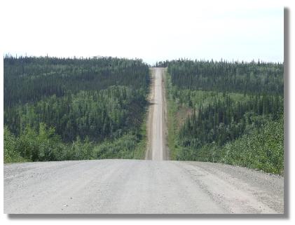 notable one today was the Roller Coaster, and just like a roller coaster it was steep and fast on one side then steep (15%) and slow up the other.
Negotiating a number of hills like this was all in the mornings work, and we eventually began to descend towards the Yukon River, covering a number of kilometres with relative ease and hoping that the downhill run would go all the way - but it didn't and before long we were clawing our way up one side before dropping back down the other, the cold air cooling the sweat dripping down our faces and making us shiver as it did.
Coming down a hill we spied a cyclist working hard coming up the hill. We stopped for a chat and met a nice German man in his late 60's or early 70's. He explained that he was on his way to Deadhorse and that the hills were really taking a toll on him, so we gave him the bad news about the hills he had ahead of him and continued on.
Some distance on and we were again out of water, so it was with some reluctance that we stopped at the Fort Hamlin Hills Creek where the water was flowing, but still a rusty brown colour. Filtering some water into our bottles and dropping in a purification tablet just for good measure we continued on up hill and down dale, hoping that the water we had would last us and that we would not suffer any ill effects, including beaver fever, from it.
With about 8 kilometres to our intended stop, a car pulls up next to us and the couple asked if we would like a drink. They told us that they didn't have any water but had some iced tea if we would like that. Well, stupid is not my middle name (contrary to popular belief) and I knew that the liquid would help with the remaining distance as between us we only had around 500ml of water left. We chatted with the man (from England) while we quoffed the iced tea down like a dying man in the desert, before he continued on, leaving two very thankful cyclists behind in his rear view mirror as he did so.
The road had turned really nasty with rocks juttingup out of the ground, the contant jiggling around was making it very hard to pedal with some sort of regular pedal stroke, and our demeanor was starting to match it. With about 2 kilometres to go to our intended stop we came to a boom gate which informed us that there was an emergency airstrip just beyond it, sort of like the Royal Flying Doctor strips in Australia, except this one was off on the side of the road, not on it. We stopped for a look, ate a museli bar and drank our last remaining mouthful of water before riding on along a very bumpy road, the smoothness of the airstrip looking very inviting indeed. And then there it was, the entrance to the Hot Spot Cafe, situated on the site of an old road camp.
Pulling into the Hot Spot we found a number of ramshackle buildings, a gift shop, motel and eatery run by two  women. Pulling up out the front we were immediately set upon by a number of motorcyclists, all with a thousand questions and wanting photos. Many of them had passed us on their way to the Arctic Circle and were amazed that we would be riding this rugged road - "it's hard enough on a motorbike" said one as he shook his head and took our photo.
Since leaving the Arctic Circle we had noticed a large number of motorcyclists on the road, who, as we found out later, leave from Fairbanks (as do the tour buses) ride to the Arctic Circle, have their photo taken and then ride back, some go all the way to Deadhorse.
Just as we were escaping from the bikers we met Ralph and Pat, they had left us last night at Finger Mountain and had ridden all the way here, arriving near midnight. Despite being around 3.30 pm, they were about to head off on their days ride, one of the advantages of 24 hours of sunlight. We booked a room, enjoyed a shower and then went and had a nice big teryaki hamburger and chocolate milkshake, a chat with the women and a look though the gift shop. The Hot Spot started some time ago when a the wife of a road worker decided to spend the summer up here with her husband and three boys rather than endure the week on, week off of his routine.
On arrival we were also warned that there was a scrawny black bear hanging around the area looking for food, so with that in mind we took all our food and other belongings inside. Tomorrow we will ride the remaining distance to the Yukon River, inspect the visitor centre and then continue on towards the start of the sealed road again and the official end of the James Dalton Highway at Livengood.
Today's Stats
From: Gravel Pit Road
To: Hot Spot Cafe 5 miles North of Yukon River
Ride Time:
4 hrs 37 mins
Distance:
55.26 km's
Av Speed:
11.9 km/h
Max Speed:
68.5 km/h
Max
Altitude:
565
m
Av Climb: 4 %
Max Climb: 15 %
Weather: 14-25 deg C
Camp Location:
N: 65:55'02.1
W: 149:49'34.7
Sunday 17 June 2007 - Fathers Day in the USA.
No two days on the road are ever the same and today sure was a mixture of many things. We started off by having breakfast and a chat with some other guests at the Hot Spot Cafe before heading off down the road towards the Yukon River. The sun was shining and it was going to be a warm one.
With no air conditioning the room was hot so with the fan going and the window open (depsite the bears in the area) neither of us had slept that well last night. We had however enjoyed a wonderful shower, getting some laundry done, having a nice meal, chocolate milkshakes and a room with a real bed to sleep in.
No more than 8 kilometres after we left the Hot Spot we came around a corner and saw our first glimpse of the bridge over the mighty Yukon River. A kilometre on and we were pulling into the Yukon River information centre, run during the summer by a retired Policeman and his wife from Florida . We stopped for a chat and a look at the exhibits before taking a few shots of the river and the bridge.

Tourist stuff over it was time to cross the mile long bridge which descends going North, causing us to climb to the other side. The deck of the bridge is made of wood and with many pot holes is in need of some repair. We eventually arrived at the other side and then immediately commenced climbing and climbing. We climbed for what seemed like hours before we eventually got to the top of the range, the lack of wind causing the sweat to pour out of us so much that at times we could not see where we were going with it in our eyes, the whole event making us feel rather like we were back in Australia and crossing the Nullarbor again.
Lunchtime came rather quickly so we found a track leading off from the road and cooked pancakes with caramel choc chips in them. After lunch, and with the sun heating the place up, it was time to try and have a nap, but with the humidity climbing no such nap happened and we pushed on.
Climbing ever higher we came to a large hill and roadworks. The road was full of bolders and we were struggling  up the 5-6% grade at 2-3km/h, riding in what was four wheel drive mode, the front wheels pushing up over rocks and causing the trike to tip, our bodies being bounced from pillar to post, the backwheel bumping over rocks bigger than a mans fist and causing us to worry about the rim and all the time trying to nurse the chain so it would not snap. The sign said there was 12 miles of roadwork and we thought we would still be there climbing in four wheel drive mode for the next week, but after about 2 kilometres of this rugged track we came to some smoother ground. Arriving at the top of the hill we were met by a traffic jam, stopped waiting for the pilot vehicle to take them through the construction site. Told by the safety man that we were not allowed to ride through, the trikes and all our gear were loaded into the pilot vehicle and transorted to the other end, some 2-3 miles further down the road. Looking at the road it was a good job too because this bit was worse than the bit we did ride and people on motorbikes had even been dropping them as they tried to ride through..
Trikes unloaded we continued through the finished part of the road and climbed another huge, long hill, lungs bursting, sweat pouring down our faces and with legs pleading for us to stop we eventually made it to the top and then through the rest of the roadworks. The roadworks is a huge project and when completed will have taken out some bad corners and dips and the surface will be sealed.
We shot down the other side of the hill fast enough to keep some vehicles behind us (probably waiting for us to crash) and about halfway down we stopped to put our wet weather gear on, the humidity had climbed enough to form clouds and we were about to get our first ride on the Dalton in the rain, and rain it did.
Riding and riding because of the rain, both trikes were getting absolutely covered in mud and muck from the road, our wet weather clothing doing such a good job that we were wetter inside than out and feeling like we were riding in a sauna. Eventually we found a small clearing to pull over in and stood there in the rain, fighting the bugs off and tucking into a can of cold baked beans followed by rice cream for desert. It was quick, easy and we didn't have to worry about cooking.
Riding on with the rain continuing we were getting slower and slower, vehicles passing covering us with mud and rivers of it running off the trikes everywhere and the fun was really disappearing fast. Coming to the top of a hill we spied a gravel track leading off towards the pipeline. We pulled in and after checking for bear activity, declared todays ride over.
The next challenge however was to get the tent up without getting it all wet. So using two tree branches that were lying on the ground, we rigged the hoochie up over them like a make shift shelter, and with one resting on the back of Joanne's trike and the other being held up by Joanne, I climbed in under the covering, unpacked the tent, rigged it all up ready to go and then with the fly over the top, we dispensed with the poles and hoochie and errected the tent, keeping the inner dry in the process. Joanne got inside to get warm and dry while I passed in the required bits from the trikes before covering the trikes and getting into the dry myself. Of course within 20 minutes of getting this all in the rain eased, but we didn't care, we were warm and dry. What a day! But you know, we wouldn't have it any other way.
Today's Stats
From: Hot Spot Cafe 5 miles North of Yukon River
To: Bush Camp
Ride Time:
5 hrs 24 mins
Distance:
47.69 km's
Av Speed:
8.80 km/h
Max Speed:
64.5 km/h
Max
Altitude:
644 m
Av Climb: 4 %
Max Climb: 15 %
Weather: 11-29-11 deg C. Hot and sunny then rain.
Camp Location:
N: 65:42.19.4
W: 149:10'43.3
