 |
 |
|
|---|
| Next Page |
| Previous Page |
Monday 18 June 2007
Today started like any other day on the road, but finished unlike any we have experienced before. Waking to a foggy morning following yesterdays rain we laid everything out to dry as the sun cleared the fog. Porrage for breakfast and then packing up and we were on our way. The road was still damp in places and following Joanne was one way to have a mud bath.
We were 50-60 km's from Livengood and that was our goal for today. We were back amongst the climbs today and as much as we enjoyed the downhills, the 3 mile uphills were taking their toll on us, the gravel, heat and gravity causing us to work hard to get up the hills, stopping frequently for a rest and the get our breath. This routine went on for most of the day. We came to some sealed road and thought that we might have found the end of the dirt, but alas no, it was just 5 kilometres of beautifully smooth sealed road and before long we were back on the gravel. Stopping for lunch at the top of a hill we again laid everything out to dry while we ate. Many vehicles, including motorhomes passed us and we must have looked quite a sight.
Lunch over we descended for about 5 kilometres before the price of all that fun had to be paid, and another 5 kilometre hill struggle was underway, but upon reaching the top we were afforded beautiful vistas of the ranges we were riding through. Another fast downhill and then we hit it, the mother of all climbs. 15% grade, gravel, traffic and another 3 mile climb. To make matters worse we were out of water so after checking and discarding the idea of filtering from the creek we squeezed the last remaining drop out of our water bags into our bottles and set off up the hill. But the fun had only just started. About a third of the way up, on a bad cambered corner the gearing on Pip decided to give me some curry. Everytime I tried to pedal the gears would mash and slip, causing me to fear that I would break the chain if I continued, the problem however was that my brakes wouldn't hold on the gravel and I was unable to get out of the trike for fear of it tipping or sliding back down the hill. Joanne was in a similiar position in front but managed to position her trike so she could get out of it, get a rock under the back wheel and come to assist me. Out of the trike I could see the chain was spread across the whole cluster, despite the de-railier being in place for first gear. Pushing the trike and pedalling it got the chain back in position but the gear slip continued - there was nothing else for it but to pedal the rest of the way up the hill in second gear, and so I did, stopping frequently to rest the legs and lungs before starting off and counting another 20 pedal strokes before stopping again. This routine continued for the duration of the hill and it was with great relief that we reached the top.
After all the drama of the uphill, we began to descend. Towards the bottom we came to some sealed road, the  sign that denoted the start of the James W Dallton Highway and the start of a new road - we had done it! We had ridden the Dalton. Joanne took some pictures of me near the sign doing the Toyota jump and it was then that a huge feeling of achievement came over us. I wanted to get some pictures of the both of us but Joanne just wanted to get to Livengood, so after taking a short video, we pressed on.
We eventually came to a sign that said Livengood 2, meaning that we had to go off the main road to get there. Being out of water again, we rode the 2 mile dirt road to a small clearing in the bush where we found a road board camp and some cabins off in the bush, but nobody around. We tried a few places to no avail, so began to ride back out and to the Livengood Creek. Filtering some water and dropping in some purification tablets we got some water before heading back out to the road where we cooked our main meal in a truck parking bay.
Meal over it was time to find a campsite, and after riding up a large hill we eventually found a track leading off into what looked like a gravel pit, so after an inspection for bear activity we commenced putting the tent up. By this time it was about 9.30 pm and we were looking forward to bed. As we were about to put our sleeping gear into the tent we were invaded by thousands of little black flies. They were getting into everything and the mozzies were taking advantage of the comotion and diving in for their evening meal - us! There was nothing else to dobut pack up and leave, so we did.
Riding on another 10 kilometres we came to a nice campsite right on the Tolovana River, where at 10.30 pm we set up camp, dodged a few more black flies and their mates the mozzies, had a wash in the river before diving into the tent to do our journals. It is now midnight, the sun is still up and it is light enough to read a book. What an interesting day, especially with 1,200m of climbing.
Today's Stats
From: Bush Camp
To: Tolovana River
Ride Time:
7 hrs 29 mins
Distance:
74.76 km's
Av Speed:
9.90 km/h
Max Speed:
70.0 km/h
Max
Altitude:
612 m
Av Climb: 4 %
Max Climb: 14 %
Weather:11-31 deg C Sunny, humid and hot
Camp Location:
N: 65:27'58.8
W: 148:19'53.9
Tuesday 19 June 2007
Awake at 6.30 am we debated whether or not to take a day off and rest the legs, but the sun was already baking us with 21 deg C, our little flies and mozzies were all up waiting for us so after laying a few things out to dry off, packing the rest, filtering some water and enjoying breakfast, we started our days ride. Of course the road immediately went uphill and that really woke the legs up. Coming to another parking bay, complete with outhouse and bear proof litter barrels at the Colorado River Trail Head, we used the facilities and then commenced another long hard climb.
After struggling up the large 5 milometre hill we coasted down a kilometre or so before arriving at the Arctic Circle Trading 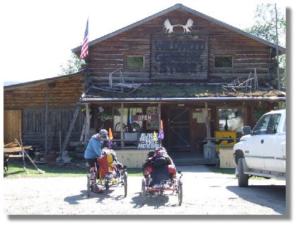 Post, a double story log cabin complete with moss on the roof. The trading post has been run by the Carlsen family (mum, dad and 23 kids - 18 adopted) for over 30 years. We stopped in for a look at all the tourist things and enjoyed a cool drink (not cold because the generator was on the blink) before heading down the hill to the Tatalina River where, with the temperature in the sun reching 31 deg C (who said Alaska was cold?), we sat in the shade, ate lunch and did some journal work.
Well distance waits for nobody so it was time to get the pedals moving again, you guessed it, up hill. The hill went up and up and up, eventually topping out after about 6 kilometres at a grade that varied between 3 and 11%. We were moving quite slow and stopping on a very regular basis. With a slight tailwind there was precious little fresh air blowing to cool us down but thankfully the trees were close to the road and there was some shade being cast, so that was where we were stopping. The hill took over an hour to complete.
A long downhill was a godsend and we were enjoying the long period of no pedalling, the trouble being that when we did have to pedal again the legs refused to work, lactic acid build up in the mucles burning painfully as we tired to get the legs to work. Bottoming out at the Globe Creek we stopped to filter some water. Leaving the trikes on the road we wandered down to the creek, announcing our presence so the bears could leave and then filtering some water into our carry bag.
Continuing on we debated whether to stop or not at a nearby turnout, but eventualy agreed to get some more distance in, and that was where the fun and hill climbing really started. For the next seven kilometres we battled up the hill, pedal stroke by pedal stroke, stopping often and wishing it was all just a bad dream. The hill was steep and our legs tired enough that we couldn't get any sort of cadence going. Joanne was doing slightly better than me and took the lead, stopping every now and then to ensure I was still following. With knees hurting, muscles burning and legs that were going numb we pedalled on, bit by bit, until eventualy we reached the turn out at the top. Taking a short rest we inspected the area for bear activity then got the stove out and a meal going. Stomachs full again we are sitting here bathed in briliant sunshine and 23 deg C and it is 9.20 pm. With nowhere to get a tent peg in, or any rocks to use to secure the tent we resorted to lashing the front of the tent to the back of the trikes and the back of the tent to the trailer, breaking our rule of having our food near our tent, but we were too tired to care.
Today's Stats
From: Tolovana River
To: Turn Out
Ride Time:
4 hrs 57 mins
Distance:
44.39 km's
Av Speed:
8.9 km/h
Max Speed:
69.50 km/h
Max
Altitude:
596 m
Av Climb: 3 %
Max Climb: 11 %
Weather: Hot andsunny. 21-34 deg C (on the road)
Camp Location:
N: 65:12'39.6
W: 148:07'47.2
Wednesday 20 June 2007
Todays ride was another one of those interesting ones (aren't they all?). Last night was a warm night and at some stage the wind picked up and blew away most of the flies that had accumulated between the tent and the fly. We started off by fighting the little black  flies for our breakfast before heading down the hill for for a change.
Not long after we left and coasting down the road I was something like a horse just wander out of the bush and onto the road - moose! I called to Joanne to slow down as she was in front but looking elsewhere. Managing to get a photo and a couple of seconds of video we watched the young moose wander off into the bush with what we presume was its mother (we didn't see it). So we can add a mosse to our wildlife listing of a caribou, bear and porcupine.
As is the case around here, we steadily climbed and climbed, enjoyed some nice downhill and despite legs that were complaining were making reasonable progress. Reaching an artesian bore that had the coldest water we have ever experienced, we took the opportunity to fill our water bags and drop a couple of tablets in there just in case. Climbing again we eventually reached the turn out at the top of Wickersham Dome, a large mountain where there is a trail you can hike or snow ski on, depending on the tiime of the year.
Downhill and straight into some roadworks where they are straightening the road, enjoying the downhill into it but not the uphill that followed. The sun was blazing and we began to wonder if we were in Alaska or Australia, we could feel the sun burning our face and sunscreen was a waste of time due to the amount of sweat we were producing. Around lunchtime we spied some shade and set up our stove near the Haystack Mountain road which also has a long roof under which there are numerous mailboxes, their little red indicator flags all in the down position informing all that there was no mail yet.. Cooking pancakes for lunch we enjoyed a rest before riding on and up. Eventually reaching the truck stop at Hilltop we enjoyed the cool of the truck stop diner, a cold drink and an ice-cream. Ringing Donnie to let him know we were in the area got us the answering machine so we pressed on.
Dropping down the hill I mentioned to Joanne that the downhill would go all the way to Fox, and it pretty well did. We stopped at the Howling Dog Inn that had been recommended to us as having nice, cheap cabins. The Howling Dog Saloon is opposite the Silver Gulch Brewery, (the most northern brewery in the USA) and has a very interesting bar, the ceiling is covered with underwear, dollar bills with peoples names on them, t-shirts, caps and all sorts of other stuff. Obtaining a cabin for the night we enjoyed a shower, cooked something to eat sitting on the porch and settled in for the night. Joanne went to ring Donnie to see if it was still okay for us to visit, returning to the cabin to tell me that Donnie was at home and coming to see us.
Today's Stats
From: Turn Out
To: Howling Dog Inn, Fox.
Ride Time:
4 hrs 16 mins
Distance:
49.46 km's
Av Speed:
8.9 km/h
Max Speed:
69.50 km/h
Max
Altitude:
626 m
Av Climb: 3 %
Max Climb: 14 %
Weather: Hot andsunny. 21-32 deg C (on the road)
Camp Location:
N: 64:57'25.3
W: 147:37'05.9
Thursday 21 June 2007
Today marks the Northern Hemisphere's Summer solstice and many people will be sitting up at the arctic circle doing their thing. On our way down there has been so many motorbikes heading North they outnumber the other road users, with exception of the trucks. Today also marks Joanne's Dad's birthday, so Happy Birthday Dad.
Sleeping in until 7.30 am we packed up in a liesurely fashion before Donnie arrived to take us to his place. He, Angie and Cheyanne live on a nice property out of town and it is here that we will be staying for a few days while we re-group, re-organise and re-supply for the next stage of the ride. We will post our departure date on our web page news ticker when we know it.
A final word about the Dalton Highway.
Make no mistake, for a cyclist, the Dalton Highway is as tough as the location of where it goes to. No matter which direction you are heading in, the mostly course gravel road has many steep grades that have to be negotiated. Heading South, much of the road is on a grade between 3 and 12% so bring your climbing legs with you.
Traffic on the Dalton is mostly trucks taking mining associated equipment of all sorts to or from Deadhorse. The truck drivers are on the whole very courteous and will lookout for other travellers and would no doubt assist if required, and with the number of trucks going up and down this road you are not alone for long, someone will always be along.
The temperature depends on the time of the year you go, but in winter it would be extremely cold and cycling seems almost impossible. Facilities such as groceries, Internet and lodging are almost non-existant with truck stop fare being the main food available at centres such as Coldfoot. Mobile (cell) phone range is non existant and satellite phone would be the only communications possibility.
The Dalton takes you through a very remote, dangerous place, and travellers should ensure they research the trip thoroughly and learn what to do if an encounter with any of the animals that call it home, occurs. Simple common sense steps should get you safely through without the need for firearms, but if having one makes you feel safer - take one, just make sure you know how to use it properly and safely.
No matter how bleak or scary the picture I have just painted it, there are no words to describe the scenery that will definately take your mind off your tired body, and have you clicking and clicking with that camera. Take plenty of memory cards - you'll need them.
When we travelled the Dalton there was a lot of roadworks, all designed to make the trip safer and obviously faster. With the eventual improved road, more and more people will travel North to the Artctic and so, like many roads before it, it will become just another road, changing forever, the unique character of it. The views and harshness of the area however will remain forever.
After completing the Dalton, regardless of wether you are heading North or South, once at the end you will, without fail, feel a huge sense of achievement, and know that you have ridden one of the harshest roads in one of the final frontiers on earth. Make sure you get one of the stickers that proudly says "I survived the Dalton!"
