 |
 |
|---|
| Next Page |
| Previous Page |
Monday 3 December 2007
Waking in the Rise Above RV was a pleasant experience improved only, by sitting and spending time with Aaron. Breakfast and more chats with Arron, Dave and Laquita saw us hit the road around 11am, the latest we have got on the road for some time, but with only a short ride to our friend Mike, we were not too worried.
Aaron, Dave and Laquita all tried out our trikes and that was enough for Aaron to decide to drive to the house and  to go for a ride on his new trike.
Leaving our new found friends was again hard and it would have been so easy to have spent the rest of the day with these people, but the road and a visit to another friend again beckoned.
Our visit with Aaron might have been short but the inspiration will last a long, long time.
Riding on into Santa Clarita we were battling along among the traffic and strip shopping malls. Aaron caught up with us and drove along as escort for a while before he turned off to go home and get a ride in on his trike.
Eventually arriving at the home of our friend Mike, we were warmly greeted and set up in his spare room, the evening being taken up with catching up on each others lives and planning the next day, eventually hitting the hay and falling asleep with thoughts of Aaron and his mission.
Today's Stats
From: Valencia RV Park
To: Newhall
Ride Time:
1 hours 30 minutes
Distance:
20.6 km's
Av Speed:
13.6 km/h
Max Speed:
23 km/h
Max
Altitude:
315 m
Av Climb: 2 %
Max Climb: 4 %
Weather: 10-18 deg C. Sunny.
Camp Location:
N: 34°22'05.3"
W: 118°30'46.0"
Tuesday 4 December 2007
Spending time with friends is always a pleasure and our time here with Mike was no different. Today was spent with Mike as he ran errands and we topped up on a few items we needed before we hit the road again tomorrow.
Newhall
Wednesday 5 December 2007
Leaving Mike's place this morning after a whirl wind but very pleasant visit, we began our day by repairing a flat tyre in the car park and then commenced our trip up towards the high desert of Mojave, and up it was. Climbing from 635m to 1033m over the day meant that the legs sure got a workout. Our road fitness seemed to have taken a beating having spent some time off the trikes when we were visiting Wayne and Kay, then the easy day from Aaron's RV to Mike's place where we had another day off, so climbing was one heck of a shock to the body when it obviously thought this riding thing was over.
Climbing out of LA through dry, bare hills and canyon's was the order of the day, the area through here so very dry and with the mercury climbing it was very much reminiscent of parts of Northern Australia. We are riding the Sierra Highway as it climbed up into the San Gabriel Mountains, most of the roads named after some nearby canyon and the surrounding area dry, dusty and lifeless. Stopping under the shade of a large oak tree we enjoyed the coolness of the shade as it brought our body temperature down and making us shiver as it did. The road throughout the trip quite reasonable and with a good shoulder for most of the way kept us off the Interstate and the humongous volume of fast flowing traffic that it carries.

Eventually arriving near the town of Acton, we stopped to utilise the loo at Macca's and then over a chocolate thick shake, decided to drop down the hill into town to see if there was somewhere to stay or to camp. Hurtling down the hill into town and hoping like hell we didn't have to climb the two kilometres back up, we arrived in a very small town with no accommodation and no campground, despite the sign near the freeway saying the opposite. Talking with a local we found out that there was a very large "dry wash" area running through the countryside near where we were and so after a stop at the vets to get some water for the night, we set off in search of a campsite.
Riding up and out of town on another, not so steep road, we were following the railway, the wash, visible on the other side of the both the railway, and, a fence, totally visible to the road and of no use to us for a camp. Bush began to appear alongside the road as the railway moved away from the road, and we began stopping regularly to investigate possible camps. The ground dry, dusty and lifeless except for some large bushes, dry grass, holes which were home to snakes and other critters, and the occasional tree.
Arriving at the intersection of the road and the freeway, a search of some possible bush turned up a possible spot. In between and under some trees was a dry, clear spot that was about the right size for the tent and the trikes. Clearing some lower branches and removing a plastic fish pond that had been dumped in there, we began setting up our camp and cooking our meal as the sun dipped below the horizon. Shielded by the bushes from both the road and the nearby freeway and off ramp, we settled in for the night, the constant drum of the freeway and the lights of passing vehicles moving over us our only disturbance.

Our campsite from a distance. The roadway just on the other side of the bushes.
Today's Stats
From: Newhall
To: Bush Camp outside of Acton.
Ride Time:
4 hours 22 minutes
Distance:
50.7 km's
Av Speed:
11.6 km/h
Max Speed:
56 km/h
Max
Altitude:
1033 m
Av Climb: 2 %
Max Climb: 9 %
Weather: 31 deg C. Sunny and hot.
Camp Location:
N: 34°29'13.2"
W: 118°08'19.5"
Thursday 6 December 2007
Our bush camp and first night in our new tent were just fine. Both of us slept reasonably well despite the continuous drum of the freeway traffic. Waking early and before the sun got up, we packed the tent before anyone saw us and then cooked some nice almond,walnut and raisin oatmeal before hitting the road.
Climbing and more climbing saw us eventually top out at 1038m and then, with the wind at our backs, the San Gabriel mountain range on our right and the town of Palmdale in front of us, we began a long downhill run that was just so good we hoped it would never ever stop - ever! But it did, and then it did, but at least we were on the flat and the wind was still behind us. Reaching the top of the climb could see Palmdale in front and the desert stretching for as far as one could see out behind it.
Passing through the outskirts of Palmdale heading towards Little Rock, we were back in the desert again, and  with the wind still blowing, came across this sign. In Western Australia cyclists chant the mantra - "its just a way of life" as they head into the wind, here they put signs up to remind you that the wind is your friend, and today, with it behind us - it is.
Despite the wind, the temperature was climbing, the sun turning the San Gabriel Mountains on our right a bluish tinge, the desert off to our left flat, dry and lifeless other than the Joshua Tree's that grow out here in abundance, as it disappeared into the distance.
Edwards Airforce Base, the alternate landing site for the Space Shuttle is also out here, the runway long and sat on a dry lake bed and at one stage we could see military aircraft overhead and then landing nearby.
Long, flat and straight best describes the road we were traveling along, the highest point being where the road crossed the railway track. Stopping for lunch allowed the wind a chance to switch direction and to come in from ahead but on a slight angle.
Leaving LA County and entering San Bernardino County meant that the road deteriorated and the nice shoulder  that we had to ride on disappeared leaving us with about 2 feet inside the white line to ride in. We were now battling the wind and the traffic. Plenty of the truckies had been giving us a friendly toot today and so we tried to ensure that we left them as much room as possible, but less than 5 kilometres out of Victorville we had a Highway Patrol car come up behind us, the officer using the speaker phone to tell us that we were holding up the traffic (he was the only traffic around) and that we should get off the roadway. Well, with nowhere other than the dirt to ride in, we stayed where we were, so he repeated the message. We pulled over so that we had one wheel on the dirt and that seemed to satisfy him and he sped off which was a pity because I would have loved to have had a face to face discussion with him about cycling, road laws (which we were obeying) and the need to share the road - as the road signs often say. We immediately pulled back out of the dirt and continued our way, traffic passing us leaving no doubt in our minds that we were not holding the them up.
So after almost 80 kilometres of desert riding which we really enjoyed, and with the threat of a huge rainstorm tonight we chickened out and found a cheap motel, albeit 7 km's out of our way and near the airport.
Today's Stats
From: Bush Camp outside of Acton.
To: Adelanto near Victorville
Ride Time:
5 hours 00 minutes
Distance:
81.9 km's
Av Spe6ed:
16.4 km/h
Max Speed:
59.6 km/h
Max
Altitude:
1038 m
Av Climb: 1 %
Max Climb: 6 %
Weather: 25 deg C. Sunny and hot.
Camp Location:
N: 34°34'45.2"
W: 117°24'40.2"
Friday 7 December 2007 - 66th Anniversary of the attack on Pearl Harbour
Overnight the wind blew its heart out and this morning the clouds on the horizon made us think twice before we finally decided to hit the road. The clouds, low, thick, dark and with white wisps had all the makings of snow or at least some nasty rain.
The wind continued to blow quite hard, the desert sand blowing everywhere as we rode off passing the airport and the Federal Penitentiary on a nice wide, smooth road, but it didn't last and by the time we turned off it had turned into one of the most shocking roads we have ever ridden on. Large ruts, cracks with raised edges and split tiled bitumen filled the road and made riding very hard, especially up hill.
Climbing up the hill and passing over the Mojave River as it trickled along, we were riding through the long strip of shopping malls, and were then into the outlying housing estates, the cold wind continuing to hit us from the side and blasting us with the loose sand from building and empty housing lots and the clouds building over the mountains as we rode alongside them.
Leaving town we again entered the deserted desert areas where the road ran between large granite mountains on one side, and the almost lifeless desert that seemed to stretch forever and right up to the mountains. Low, thin bushes dotted across the desert floor made for slight cover for toilet breaks, but we still had to make a fair trek off into the desert for privacy.
With the wind continuing to belt us as we rode, we came to Rabbit Lake on the outskirts of Lucerne Valley, the lake could have been called Chocolate Moose Lake because of the thick brown water that the wind was whipping up. The mountains off to the right helping funnel the wind down the valley and the light wispy cloud down the ridges looking like smoke.

Arriving in the small town of Lucerne Valley with the clouds building and darkening over the mountains and the wind blowing its heart out we found the first motel closed and under renovation, but the second open for business. Checking the weather forecast showed more snow in the mountains and another couple of cold fronts heading through California, and our way. Looking out from the motel there is snow on the mountains which we figure will become more and more obvious. The weather is no surprise however, after all, despite the sunshine, it is winter here.
Riding through the desert has been a wonderful experience, the place has got a charm similar to that of the Kimberley in Australia, the rock formations and emptyness of the place touching something inside and we are looking forward to seeing and experiencing more.
Today's Stats
From: Adelanto
To: Lucerne Valley
Ride Time:
3 hours 25 minutes
Distance:
48.5 km's
Av Spe6ed:
14.1 km/h
Max Speed:
51.5 km/h
Max
Altitude:
937 m
Av Climb: 2 %
Max Climb: 10 %
Weather: 5-15 deg C. Sunny and windy.
Camp Location:
N: 34°26'39.8"
W: 116°58'10.8"
Saturday 8 December 2007
A dusting of snow on the nearby mountains and a cool 5 degrees C greeted us this morning as we commenced  our ride today, the town of Lucerne Valley still waking up as we rode back out into the desert. The cool wind blowing behind us helping us ride and the clouds overhead threatening to dump on us.
Riding through the mostly deserted desert was a very pleasant experience, the cold air, lack of traffic down the long road coupled with the sparse desert vegetation and the occasional Joshua Tree gave us the impression that we were alone in the vast empty countryside - and we were for many a mile.
Riding along through the flat terrain was a pleasure, especially with a tailwind, a 17.9 km/h average testament to the ease with which we were riding, until we took the turn off to the small town of Landers, where, we thought there would be somewhere to stay out of the third low level weather system that was headed our way.
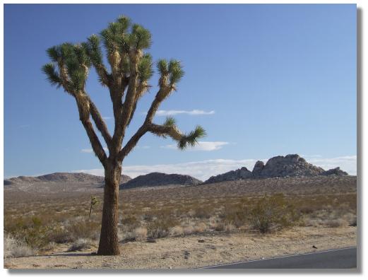
High Desert Joshua Tree
Scooting down the 3 mile hill into town resulted in our being told by two men that there was no accommodation in town, and then by a woman that there was a motel but it was full of undesirables and she would not recommend our going there. So with no alternative and not wanting to ride back to the highway via up the long hill we had just come down, we headed out of town via the back road. Riding through homes on acreage we were immediately into a headwind. The road was reasonably quiet and used by locals staying off the highway, and then we turned to rejoin the highway and struggled against both the wind and the 5% grade.
Eventually arriving at the highway we stopped for a rest before heading towards town. A road sign showing an 8% downhill lifted our spirits as we began our descent into Yucca Valley, the town laid out before us glistening in the desert sun and surrounded by the mountains of the Joshua Tree National Park. The first motel we came to got our patronage and with aching legs, especially knees, we booked in as the skies darkened and began to look very menacing.
Today's Stats
From: Lucerne Valley
To: Yucca Valley
Ride Time:
5 hours 32 minutes
Distance:
82.78 km's
Av Spe6ed:
14.9 km/h
Max Speed:
60.0 km/h
Max
Altitude:
1149m
Av Climb: 2 %
Max Climb: 7 %
Weather: 5-11 deg C. Sunny, windy and cold.
Camp Location:
N: 34°07'18.6"
W: 116°25'08.6"
Sunday 8 December 2007
Day off in Yucca Valley.
Yucca Valley