 |
 |
|---|
| Next Page |
| Previous Page |
Monday 10 December 2007
The wild storms that have been belting the US finally passed over yesterday, snow falling outside as we watched, and by this morning we had clear skies and a cold wind blowing. Leaving Yucca Valley we were riding along Highway 62, a four laned highway carrying a reasonable amount of traffic.
Riding with a general downhill bias we were making excellent progress towards 29 Palms - a small town some 30 kilometres away. Having decided to take an easy day and to stock up on food and water for our trip through the most desert we have ridden through. It also gave us the excuse to have an easy day for our 30th Wedding Anniversary.
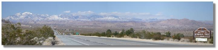
With only one hill to climb we slowly got to the top, slowed by the cracks in the road that really showed how much work they need to do on the road, the traffic making a thump, thump, thump sound as it passed us. Climbing up we could see a nice view unfolding and unfolding as we climbed, then as we reached the top and looked back, there it was, the desert town of Joshua Tree at the base of snow covered mountains, and all under a brilliant blue sky. The view was such a pleasure to look at as we ate our museli bars before continuing on to town.

Today's Stats
From: Yucca Valley
To: 29 Palms
Ride Time:
2 hours 10 minutes
Distance:
39.81 km's
Av Speed:
17.80 km/h
Max Speed:
60.50 km/h
Max
Altitude:
1024m
Av Climb: 2 %
Max Climb: 9 %
Weather: 5-10 deg C. Sunny and windy.
Camp Location:
N: 34 °08'11.2"
W: 116°04'47.3"
Tuesday 11 December 2007
The cold desert air was blowing as we left town this morning, thankfully from behind us. Leaving town with its almost deserted streets, we were quickly back out into the desert proper, the road with a downhill bias providing for easy riding, so easy that we were averaging 18 km/h, a very unusual average for us, despite the pair of us having two large bags of water onboard, a total of 20 plus litres.
Riding through the desert was a real pleasure, despite the only things to look at being the surrounding ranges  and very little in the way of vegetation. Making great progress we commenced climbing Clark's Pass, the climb also meaning we would change direction and battle into a headwind.
Stopping for lunch in a dry creek bed we enjoyed the shelter the banks and small shrubs provided while we filled our fuel tanks, the surrounding ranges giving us a pleasant view to look at while we did so.
Lunch over we recommenced the climb, a military jet aircraft from nearby Marine Corps Air Combat Training Area sweeping fast and low across the road as we climbed. The view of the valley between the mountain ranges beautifully bare as were the surrounding mountains and going and going as far as the eye could see, and the higher we climbed the more spectacular the view became. Arriving at the top, and with a very cold wind blowing, we began to descend, the road going straight as an arrow and laid out in the valley floor below. Cruising down the road without the need to pedal was a real pleasure, our speed being maintained around 40 km/h - pity it couldn't be so easy all the time!

Looking for a campsite we spied a rocky outcrop near the road so an inspection was a must, sunshine, seclusion and a place out of the cold wind being the main criteria. Nothing being found near the rocks a quick look over the other side showed exactly what we were looking for, wheel marks in the basin also indicated that there was a track in somewhere further down the road. Sprinting back to the road before the traffic coming up the road saw what we were up to, we rolled down to the track and then with no traffic around, quickly rode down the sandy track, removed the flags and got the trikes behind the rocks and out of site of the road. Our normal bush camp actions to make sure that the less people possible knew where we were had worked well, even though there was hardly any traffic.


Walking around the area showed that many others had camped there, fire pits and empty weapons shells evidence of camping and shooting by previous inhabitants. Locating a nice spot out of the wind and with some sunshine, we set up camp and settled in for the rest of the day. Taking some time to explore around, climbing around on the rocks provided magnificent views of the area and tomorrows ride.
As the afternoon wore on the sun began to dip in the sky and dropped behind the rocks that were shielding us, long shadows and a cold desert wind invaded, sending us into the tent to keep warm. We remained in the tent and only came out to cook, clean and pack up before quickly heading back inside for the warmth and comfort of the sleeping bag as the glow of the last rays of the sun turned the surrounding hills pink.
Today's Stats
From: 29 Palms
To:Desert Camp Sheephole Wilderness Area
Ride Time:
4 hours 18 minutes
Distance:
67.53km's
Av Speed:
15.6km/h
Max Speed:
54km/h
Max
Altitude:
695m
Av Climb: 2 %
Max Climb: 7 %
Weather: 5-13 deg C.
Sunny with cold wind
Camp Location:
N: 34°05'36.6"
W: 115°24'31.3"
Wednesday 12 December 2007
Being on a less traveled road, and in the desert, the silence last night was louder than any of the few vehicles that passed by throughout the night, and a nature call meant that we were able to enjoy one of the most magnificent views of the sky that we have ever seen - a loo with a million star view! Stars dotted all over the sky like small diamonds on a deep black velvet, orange planets near the horizon and the occasional aircraft all made for wonderful viewing, but no matter how good the view was, the low temperature quickly sent us back inside to the warmth of the sleeping bag where we star gazed for a while through the tent's moon roof.
Waking to a 2 deg C morning we packed up and enjoyed the warmth of the morning sun as we ate breakfast. Cleaning up the camp and departing as the sun gained some intensity, we again enjoyed rolling downhill for around 12 kilometres with a tailwind, sort of a cyclists Nirvana, the road continuing straight as an arrow and threading its way through the desert, the nothing growing higher than a few feet and only a few vehicles passing us.

And then all too soon the downhill was over and we commenced climbing up towards Granite Mountains and the corner of Highways 62 and 177 and where we would turn off towards Desert Center.
On the way up the hill we stopped to view the California Aqueduct, a long concrete channel that takes water through the desert. Climbing up onto the bank afforded us magnificent views of where we had ridden. Continuing up the 3% grade that went for 5 kilometres, the expenditure of energy keeping us warm from the cold desert wind that was still following we could see the turnoff tantalisingly close ahead.

Eventually arriving at the top we stopped for a break and to enjoy a snack before turning off of Highway 62 onto Highway 177, the wind now coming from the side and chilling us to the bone as we rode, or I should say, coasted, downhill yet again. As before, the road was as straight as an arrow, heading off into the desert between the surrounding mountain ranges, the traffic slightly busier than before but just as courteous, many giving us a friendly toot as they passed.
Continuing downhill for another 12 kilometres we passed a monument which had an old World War 2 US Army helmet cemented on the top, the plaque telling how over a million men were sent out here to be hardened up for war against Nazi Germany and Imperil Japan. Over near the mountains we could again see the aqueduct, this time as it ended its open air travel as it went underneath the mountains in a tunnel.
Bare, unusable, dry and almost lifeless desert was still our office as we rode towards Desert Center where we would join Interstate Highway 10. Riding past some farms we could see where they were now and had tried before to grow some crops and other items, the lifeless dreams lying in ruins and now just a monument to man's foolhardiness of trying to grow things in the desert.
Having cheated a little and looked at the area on Google Maps the last time we had Internet access, we knew that  there was nothing at Desert Center except a truck stop, cafe and Post Office, so with plenty of water onboard decided to take an afternoon off. Finding ourselves a campsite down a sandy track which was too soft to ride, we resorted to pushing the trikes, the exercise reminding us why we don't like to push them.
Setting up camp behind some bushes and shielded from the road, we sat enjoying lunch and a coffee, seven streaks in the sky indicating seven airliners as they went on their way, and then there was the unmistakable roar of a military jet, and then there were two, streaking low and fast across the mountains as they played chase the leader and providing us with some lunchtime entertainment.
Today's Stats
From: Desert Camp Sheephole Wilderness Area
To: Desert Camp 8 km North of Desert Center
Ride Time:
2 hours 58 minutes
Distance:
54.60 km's
Av Speed:
18.3 km/h
Max Speed:
43.5km/h
Max
Altitude:
507 m
Av Climb: 2 %
Max Climb: 7 %
Weather: 2-21 deg C.
Sunny with cold wind.
Camp Location:
N: 33°45'28.9"
W: 115°20'59.1"
Thursday 13 December 2007
Another very quiet, cold night in the desert passed as we were snug as a bug in a rug in our tent. Waking to a cool clear morning we pushed the trikes back out to the road and commenced the 8 km ride up a very slight but taxing hill to Desert Center.
Arriving in town the first thing  we noticed was that the place was almost lifeless and had seen better, more profitable days. The main street, once the Interstate Highway was now dusty and empty except for a few trucks, their drivers taking a break from the drive, the buildings old and in need of some tender loving care having seen the best years some time ago.
Stopping at the Desert Center Cafe for a toilet break, we walked inside and felt like we had gone back to the 1940 or 50's. The old cafe with its metal framed, marble laminate tables and chairs sat lifeless awaiting patrons, and the small stools with their torn red leather seats fixed in place along the main counter instantly brought to mind visions of people sat there drinking coffee being served by a woman in a pink dress, white pinafore and hat while she chewed her gum or smoked a cigarette - just like in the movies.
Break over we rode over to the new Interstate Highway (10) and began to ride down the nice wide shoulder, the traffic whizzing by, truckers tooting and almost to a tee, moving over to the outside lane to pass us. Views of where we had just ridden and the continuing mountain ranges gave us something to look at as we rode along.
We were riding towards a highway rest area by the name of Wileys Well Rest Area, and as we approached we  saw a very interesting sign informing of the State Prison and the need not to pick up hitchhikers, and then just 50m after that there was the sign for the rest area. Pulling into the rest area we sat under the pergola and enjoyed lunch and a couple of coffee's.
A walk out the back of the rest area turned up a wilderness area behind a long, large bank of dirt, low bush, sand and water runoff's.
Riding out of the rest area we investigated the area, riding, pushing and dragging the trikes around trying to find a campsite. We found one but there was a really weird feeling to the place so we did what we always do when one or both of us feel that way, we left, eventually finding a spot at the back of some trees near the back fence of the rest area. Settling in for the afternoon and evening we fell asleep to the constant hum of the highway.

Today's Stats
From: Desert Camp 8 km North of Desert Center
To:Wileys Well Rest Area
Ride Time:
3 hours 26 minutes
Distance:
58.08 km's
Av Speed:
16.8 km/h
Max Speed:
29.5 km/h
Max
Altitude:
270 m
Av Climb: 1 %
Max Climb: 4 %
Weather: 4-21 deg C.
Sunny with cold wind.
Camp Location:
N: 33°36'39.3"
W: 114°54'02.6"
Friday 14 December 2007
A cold desert wind was blowing as we awoke this morning, the sun, rising in the sky almost defence less, its rays taking some time to warm us up. Leaving the rest area we again rode along the Interstate, the truckers still being very courteous and tooting, even from the other side of the highway.
Taking the obligatory turnoff for cyclists we turned onto a local road that passed the airport, the sign out the front the newest item there, the rest looking rather tired. Riding past the Border Patrol Headquarters and then through hay and vegetable growing areas brought us into Blythe, a puncture just out of town annoying, and then as we stopped to discuss the name of the motel, Joanne noticed another puncture, this time on the Bob trailer.
Booking into the motel we took the chance to remove all of the panniers and the trailer before riding the 2 kilometres into the Supermarket and a chance to look at the town. Armed with plenty of fresh food and goodies, we rode back to the motel and enjoyed a nice hot shower.
Blythe is just near the Colorado River and the border to Arizona, and it is where we are going to stop riding for a while so as to allow us to visit our good friend Bob. Bob is in the US for work reasons but is taking a few days off at the end of it to see Las Vegas, so, so will we. We are hiring a car to drive up to Vegas and will be staying at the Treasure Island Casino/Hotel. At this stage we will be back on the road on the 23rd of December.
We are back from our side trip to Las Vegas and will be back on the road tomorrow.
Today's Stats
From: Wileys Well Rest Area
To: Blythe
Ride Time:
2 hours 11 minutes
Distance:
32.81 km's
Av Speed:
14.9 km/h
Max Speed:
31.5 km/h
Max
Altitude:
155 m
Av Climb: 1 %
Max Climb: 7 %
Weather: 2-15 deg C.
Sunny with cold wind.
Camp Location:
N: 33°36'34.4"
W: 114°36'29.8"
Sunday 23 December 2007
Leaving Blythe this morning after a week off we were immediately reminded by our bodies that such rest from the rigours of the road, whilst so utterly enjoyable, comes with a price which is payable the first day back on the road.
The moment we left Blythe we were climbing, not a great big grade or anything so daunting, just a slight uphill that went forever, and joined with a cold headwind, really made us work hard - all day. Not far out of town we came to the almost dry Colorada River which not only supplies the surrounding area with water but also serves as the State line for California and Arizona. We were riding Interstate 10 and the traffic was heavy, many people heading off for their Christmas holidays, loaded to the gunnels and then some as they made their way along the highway.
Almost as if on cue, the scenery changed once we crossed the state line, gone was the the almost barren desert  and in came a landscape dotted with small climps of grass, creosote bush and various catus, the largest, the tall and often branched Saguaro Cactus and the smaller, fluffy looking Ocotillo. The soil also became redder the further we rode, and the blend of red soil, ranges, cactus and big blue sky made for a wonderful picture, and minus the cactus, the scenery was somewhat similiar to the Kimberley in Northern Australia.
Arriving in the town of Quartzsite we stopped to pick up some water and then rode through the edge of town and back to the Interstate, passing as we did, many tents and displays for the gem, rock and jewellry fest that was in town. Back out with the traffic the continued to climb, Joanne's legs protesting severly and slowing us down to around 9 km/h with many rest stops to relieve the ache and to allow us to enjoy the scenery.
Finally reaching the top of the range we descended down the other side into a valley, the sun highlighting various parts of distant ranges and providing many photo opportunities. Riding towards the town of Brenda we spotted a gate minus the customary "No Trespassing" sign replaced instead with a "Please Shut the Gate" sign. The bush behind the gate looked inviting so we rode in, closing the gate behind us and eventaually found a nice spot behind some bush that was well away from the road and out of the wind. The area around us has many Saguaro Cactus standing up tall andthe area is littered with dark brown volcanic rocks, and with the interstingly shaped ranges with their flat tops made for a very nice campsite.
Today's Stats
From: Blythe CA
To: Bush Camp 5 km W of Brenda AZ.
Ride Time:
5 hours 5 minutes
Distance:
62.34 km's
Av Speed:
12.20 km/h
Max Speed:
41 km/h
Max
Altitude:
521m
Av Climb: 1 %
Max Climb: 11 %
Weather: 7-19 deg C.
Sunny with cold wind.
Camp Location:
N: 33°40'18.9"
W: 113 °59'21.4"