 |
 |
|---|
| Next Page |
| Previous Page |
Monday 05 November 2007
Sleeping under the gum trees and on a comfortable bed of eucalyptus leaves we awoke this morning to fog, and lots of it. Everything was dripping wet and the cool morning air was quite uncomfortable to be in. Breakfast was with three other cyclists, Ian, Ryan and Erica. They are riding from Olympia in Washington and are heading down the coast to San Diego.
Riding early in the morning was nice as far as low traffic conditions were concerned and it was just as well that it was low as visibility was down to the minimum. Climbing up out of town past the small shops and the fishing boat area we continued our climb up through the fog, anxious moments were plentiful as we rounded blind corners and prayed that nothing would come up behind us.
Stopping in the small town of Valley Ford to use the portaloo outside the store allowed us time to rest from the climb and the fog, to clear. The fog was a large bank that resembled a huge bank of cloud and with the wind pushing it it was moving quite quick. Turning off the highway we began riding through open dairy farm land, the road was in not so great shape which with the hills added to the workload as we passed through eucalyptus tree areas. In fact there all the trees were eucalyptus and we could have been forgiven for thinking we were in Australia.
Arriving in the small but very nice looking town of Tomales was a pleasure, the shop fronts neat and tidy and looking like they do in a western movie, the homes matching the same period and looking very well kept. Of interest was a building that resembled a bank, but the sign over the door said "Not a Bank".
Leaving Tomales and riding through a canyon towards the coast we were battling the wind as it was funneled up  from the coast. Eventually getting through the canyon we arrived at Tomales Bay where the water had made small channels through colourful soft vegetation.
Tomales Bay is a large oyster, clam and fish area, the bay around 10 kilometres long, its shores home to many seafood shops and homes perched on the small sliver of land between the road and the water, all with magnificent waterfront views and probably worth a packet.
Stopping for lunch in the small town of Marshall we sat in the sun over looking the bay as it sparkled in the sunlight.
More shoreline riding and climbing before we arrived in the town of Pt Reyes where we missed our turn to follow the bike route because of going into town to the supermarket. A few kilometres out of town we were again climbing a long tall hill, the sun adding to the effort required to get to the top, buckets of sweat coming out of us as we gradually climbed to the top of the open grassland hill. A quick descent saw us arrive at the bike path that has replaced and old railway line, taking us off the roadway and into the cool of the redwood trees as the pathway followed the creek towards our destination, the Samuel Taylor State Park.
FInding the park and the hiker/biker sites we were setting up camp as Duhane arrived. He has been riding down from Vancouver and was on his way to San Francisco. We enjoyed a chat and then Gunner, another of the cyclists at the camp last night, turned up and joined us for a while. Then, as we were discussing the way ahead with Gunner, Ian, Ryan and Erica turned up. So two became three, became four, became seven, a real cyclists campsite. We all set up camp, cooked and ate before spending the evening sitting around the camp table chatting about various rides, the way ahead and all manner of cycling topics - a real pleasant and fun evening.
Today's Stats
From: Bodega Dunes State Beach Campground
To: Samuel Taylor State Park
Ride Time:
5 hrs 6 min's
Distance:
67.04 km's
Av Speed:
13.1 km/h
Max Speed:
59 km/h
Max
Altitude:
110m
Av Climb: 4 %
Max Climb: 16 %
Weather: 8-18 deg C. Sunny.
Camp Location:
N: 30°01'17.9"
W: 123°44'05.5"
Tuesday 6 November 2007
Despite our late night we awoke around the same time and slowly emerged from the tent. Duhane turned up from his camp all packed up and ready to go and the others were all getting up to start their day. Packing up and enjoying breakfast we stood around enjoying the company, talking bikes and cycling. Duhane, Joanne and I departing before the others and working our way along the horrible road out of the State Park.
Making our way through the small towns of Lagunitas, Forest Knolls, and San Geronimo we climbed the largest hill  for the day before speeding down into the town of Fairfax and the suburbs of San Francisco. Continuing to follow the bike route we were assisted on our way by a local who figured that as we were looking at a map that we needed help. He rode along with us to make sure we took the right turns and then as Ian, Ryan and Erica turned up he left us to our devices. Stopping for lunch at a deli we were surprised to find they stocked many Australian items such as Tim Tams, Aussie wines and other things from home, almost like an Australiana shop in San Francisco! We all bought lunch in the shop and then sat outside in the car park eating it and enjoying the sun and the company.
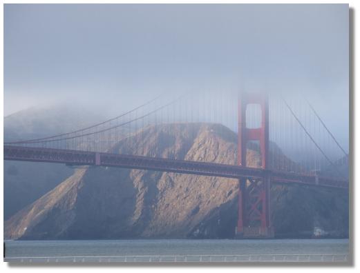
Our bike route map took us through the quieter back streets of San Anselmo, Ross, Larkspur and other small communities before we commenced climbing and climbing up through the narrow streets towards the Marin Headlands and the Golden Gate Bridge, all the time the large bank of fog was rolling in like a large cloud, spilling over the top of the oceanside cliffs and rolling down the other side, giving the impression of dry ice spilling over the top of the vessel it is in.
Stopping at the vista point we donned jackets and more clothes as we stood there watching the fog engulf the big red bridge. Somewhere in our visit someone pinched the flag off of our Bob trailer leaving us sad at the loss of something that had made the whole trip from the Arctic Ocean. With the view of the bridge still obscured by the fog we were watching the sun highlight the city, suburbs and the bay itself, almost as if the fog stopped as soon as it hit the bridge.
Photo session over we began our ride across the bridge in convoy fashion, dodging the walkers and those who had hired a bike to ride rather than walk over the bridge. Traffic was heavy coming over the bridge as we made our way across on the pathway, the sheer number of vehicles enough to make one marvel at how strong the bridge was, not only supporting itself but all this traffic as well.


Getting to the other side of the bridge we stopped to inspect the gift shop with its plastic bridge models, t-shirts and other tourist junk before we parted company with Ian, Ryan and Erica, they off to their friends place and us off to find somewhere to stay in the city.
Not really knowing where we were going we started to head off in the direction of the city, stopping halfway down a hill to look at the map. A passing cyclist stopping to assist and putting us on the right trail to get us in the accommodation district. Dropping down the hill to Crissy Field, an old military base. Cruising along the bike path towards the motels we stopped to look at the map to locate the street we needed to turn into when a man stopped and gave us some help, suggesting that we might like to stay in the Fort Mason Youth Hostel. He then proceeded to ring the hostel to see if they had a room for us - which they did.
Continuing to follow the bike path and with Alcatraz Island seemingly so close to the shore we eventually climbed the hill and arrived at the hostel. Booking into a room to ourselves, overlooking San Francisco Bay, we unloaded the trikes and locked them in the bike room right alongside the two wheel recumbent belonging to our German cyclist friend - Alex.
Today's Stats
From: Samuel Taylor State Park
To: Fort Mason Hostel San Francisco
Ride Time:
4 hrs 2 min's
Distance:
51.82 km's
Av Speed:
12.8 km/h
Max Speed:
56.5 km/h
Max
Altitude:
173 m
Av Climb: 3 %
Max Climb: 17 %
Weather: 10-18deg C. Sunny.
Camp Location:
N: 37°48'25.1"
W: 122°25'42.7"
Wednesday 7 November 2007
We called a rest day in San Francisco to take advantage of the facilities at the hostel. We were very lucky to have snared a room on the waterfront and just a 5 minute walk from the heart of Fisherman's Wharf, the tourist hotspot of San Francisco. Our hostel was up on the hill and our room looked over the bay and through the trees we could see Alcatraz and when the fog lifted, the Golden Gate Bridge.
Alex went off to do the tourist thing while Joanne and I rang some bike shops to try and find the tyres we were  looking for and a replacement cassette hub body - all to no avail. Following on from our lack of success in the bike parts area we walked down towards Pier 39 and the tourist spot. Having visited the place 9 years ago it was like a trip down memory lane, and we took the chance to eat lunch in the same Denny's restaurant under the hotel we had stayed in back then. Walking through the tourist area was fun and also allowed us to buy a filter and wide angle lense for the camera, now all we have to do is learn how to use it properly.
Returning to the hostel we hit the Internet and called all the bike shops down the coast again looking for the tyres and cassette hub body again before relaxing and looking at the maps for the trip ahead. Having a spare bed in our room we were in a great position to offer that bed to Alex who had to leave because the hostel was full, and so we shared our room with him. The evening was spent sitting in the cafe chatting and planning the trip ahead before we all retired to get some rest ready for the ride the next day.
San Francisco
Thursday 8 November 2007
Breakfast was included in the price of the room so like yesterday we enjoyed some bagels and drinks in the cafe before getting the trikes out of the bike room and packing them while taking up most of the hallway near our room. Packed up and ready to go we rode the trikes to the front desk, checked out and rode off back down the bike lane through Crissy Field amongst the other cyclists, joggers and other San Franciscans' and back up to the Golden Gate Bridge to recommence following the bike map and route.
Heading South from the City allowed us the chance to view the bridge again, this time with no fog over the top, and then as we came out along the coast we enjoyed a vista of the oceanside approach to San Francisco.

Dropping back down towards the ocean we rode through the suburbs with the steep streets, houses all very similar and all seemingly connected by a spiders web of electricity and cable TV wires between them. Arriving at the ocean we were riding along the coast road with a large sand dune between us and the ocean, and then, just when we were enjoying the flat riding a hill or two came along to really make us work hard. We were riding up into the suburb of Daly City were sitting on the headland were rows and rows of houses almost identical and sitting on blocks of land that were quite steep. The bike route took us off of the highway and up through the suburb on quiet streets. Eventually reaching the top of the long 7% climb we enjoyed an equally long and fast downhill through the streets, our legs enjoying the rest on the way down. Stopping at the shopping centre we stopped to buy some lunch and then rode a block to the beach to enjoy our food, and where Alex spotted a dolphin swimming by.
Leaving town we then worked out way along the highway to towards Pacifica and the climb up the Devils Slide, a steep, narrow road amongst the traffic. With legs that were quite sore from the climb we stopped at the top to take some photo's of the coastline before coasting down the equally long, narrow descent with some interesting corners. All of the motorists passing were using some common sense but one in a white van decided that I was not over far enough so began tooting his horn at me. Looking at the road and where I could safely ride I decided that he would just have to wait, so when continued to toot his horn I moved over into the middle of the lane and just let him stay behind me, pulling over to the shoulder when it finally appeared and hoping that he would do the same, or that maybe we would meet later on for a discussion, but that never happened.
Arriving in Montara around 3pm Alex, Joanne and I decided that it was going to be late by the time we made it to  the campground further down the road so we decided to share a dorm in the hostel.
Riding on, we found the Lighthouse and the hostel that was attached and as luck would have it, there was a three bed room available, so we grabbed it, storing the trikes and Alex's two wheeler in the shed that was originally the generator shed.
Today's Stats
From: Fort Mason Hostel San Francisco
To: Montara Lighthouse
Ride Time:
3 hrs 21 min's
Distance:
42.21 km's
Av Speed:
12.5 km/h
Max Speed:
59 km/h
Max
Altitude:
191 m
Av Climb: 4 %
Max Climb: 11 %
Weather: 10-15deg C. Overcast.
Camp Location:
N: 37°48'25.1"
W: 122°25'42.7"
Friday 9 November 2007
Last night we spent a very pleasant night in a very congenial location. The hostel was quite busy and yet it never felt over crowded and there was plenty of room for all, the modern decor pleasant and welcoming.
Leaving our cosy hostel we rode through town and on towards Half Moon Bay, a short but pleasant nondescript ride. Approaching town a man stopped us and told us of a good bike path that took us away from the highway and along the beach, and it was a great ride through the dunes and along the oceanside, totally devoid of vehicles and traffic.. Arriving at the campground on the beach we took a tour of the grounds marveling at how close the campsite was to the beach before taking a short ride into town where we shopped for food and made a quick stop at the bike shop. Shopping over it was back to the campground to take up residence in the hiker/biker place, enjoying the fact that it was an open sunny area and not the forgotten area up the back of the forest.
Setting up camp under the tree we began the small list of chores that we had assigned to today when another touring cyclist - Jamie, turned up. Jamie is also from Perth in Australia and began his tour in Anchorage Alaska. We spent a pleasant afternoon chatting before Alex turned up and added to the group. We all camped together and spent the evening chatting about cycling, bikes and touring.


Today's Stats
From: Montara Lighthouse
To: Half Moon Bay CG
Ride Time:
1 hrs 35 min's
Distance:
19.06 km's
Av Speed:
11.9 km/h
Max Speed:
25.5 km/h
Max
Altitude:
51 m
Av Climb: 2 %
Max Climb: 9 %
Weather: 10-21deg C. Sunny.
Camp Location:
N: 37°28'11.7"
W: 122°26'45.3"
Saturday 10 November 2007
One of the great things about being foot loose and fancy free living on the road is the way each day is so different and you never know what the road, the day or someone will throw at you, and to roll with the punches is often an interesting experience.
Leaving Half Moon Bay before Alex and Jamie, Joanne and I rode more of the bike path before rejoining the  highway. Staying along the coast was pleasant but the road still had its fair share of climbs as it wound its way along, often over various headlands and close to the trip.
Grey overcast sky and a strong headwind dampened the day somewhat but the kilometres seemed to flow reasonably well, and stopping at various state beaches for a rest and something to eat also helped the day pass, although the cool wind ensured that we didn't spend too much time sitting around cooling off.
Today's plan was to ride towards the Pigeon Point Lighthouse which was again in the Hostelling International chain, and if that was full, to ride on to a private campground where they boast luxurious conditions for campers including heated tent pads and even a sauna for campers and for those who want to upgrade to a cabin - a maid service.
So after arriving at the Lighthouse to find it full, we rode on to the other location (which shall remain nameless). Having tried to contact this particular location over a three day period and having wasted a few dollars using public phones - just to end up listening to an answering service we rode on hoping to secure a luxurious site. Arriving at our second choice we rolled into the driveway only to find that the place was totally booked out for a wedding. Pity they didn't put that on their answering service! With no Plan C, we sat in the car park to the coastal State Park watching the people arrive for the party, and awaited the arrival of Alex and Jamie who turned up around 4pm.
Deciding to go back to where Alex had been told there was a State Park with camping we turned back in the direction we had come from and the rain came in to add to the day. "Two miles" was the direction we were given but after riding a back country road for what seemed an eternity, we climbed some hills, descended the other side and just after we thought we were on the wrong road we found the sign to the park. So there we were, riding in the rain, climbing more hills, passing through more redwoods and now in the dark the four of us arrived at the walk in camping spot where, after an inspection of where we were supposed to put our tents, we decided on camping where you would normally park your car because it was drier and the water would drain away.
So there we are, four drowned rats, standing in the campground, no light from the sky at all, the redwood trees making things even darker, the rain falling quite hard, wondering how we were going to achieve a dry, warm resting place for the night and what we were going to have to eat - and when.
Picking out the places for the tents, we decided that we would put our tents up one at a time, the others would hold the hootchie over the top while the owner erected the tent and got their gear inside, and so we did, repeating the process successfully three times. So now we had dry beds and somewhere to sleep, the next item on the agenda was food, and with the rain continuing to fall, and not wanting to cook or even eat in the tent, we decided on a dry meal of energy bars and sweet biscuits finished off with a bottle of beer that Alex had bought earlier - hardly the meal of champions, but the best and most simple considering the circumstances.
Eagerly covering the trikes and bikes, we got into the tent, discarding and stacking our wet weather clothing in the vestibule on the way in, then hanging the other bits around the tent in the vain hope that they would dry somewhat overnight. Then, as we were starting to get warm in bed, the camp host turned up asking if we had paid for the site - to which we said no because the sign said to select a site and then return to pay for it at the registration point about a kilometre away at the gate and we were not going to spend any more time in the rain than we had to, so we just paid her the $3 each through the tent door and off she went, leaving us alone as the rain pelted on the tent.
Today's Stats
From: Half Moon Bay CG
To: Butano State Park
Ride Time:
4 hrs 10 min's
Distance:
53.08 km's
Av Speed:
12.7 km/h
Max Speed:
56.5 km/h
Max
Altitude:
134 m
Av Climb: 3 %
Max Climb: 15 %
Weather: 10-15deg C. Overcast.
Camp Location:
N: 37°12'39.9"
W: 122°19'43.9"
Sunday 11 November 2007
The rain continued to fall overnight but by the time we were ready to get up there was just the drip, drip, drip of rain from the trees overhead. Emerging from the tent into a cold, damp morning we began to pack up and to get out of the forest and out into the sun which we could see over the tops of the trees around us.
Leaving before Alex and Janie, we quickly descended out of the park, surprised at the steepness of the climb last night before bursting out into the sun, its warmth so wonderful on our skin and immediately raising not only the temperature, but also our spirits by a number of degrees.
Climbing the hill back to the point where we had turned back yesterday, we had already covered 9.9 kilometres and in some way felt that todays ride was just starting. More coastline riding and beautiful views under a briliant blue sky and we arrived in the small town of Davenport where we stopped for lunch, sitting in the sun and looking out over the ocean.
Continuing on towards Santa Cruz we were again travelling along the coastline, many parts of which are farmed between the ocean cliffs and the road. Arriving in town we managed to locate the hostel high up on the top of a hill tqo blocks away from the beach. Not being able to book in until 5 pm we rode down to the beach and hung our wet tent and other items out on the railing that runs along the beachfront. Many of the homeless were also on the beach or walking past us. One woman stopped and told us that we were not allowed to camp on the beach as it was a fine or jail for doing so, but then told us that it is okay as they do it all the time. Walking off she wished us well and then walked straight into a metal light pole!
Tent and other items dried and more homless and others starting to hang around were enough for us to head back to the hostel where we met up with Alex and Jamie, booking in and sharing a suite with them ensuring that we had comfort, our own bathroom and a cheap price to boot.
Today's Stats
From: Butano State Park
To: Santa Cruz
Ride Time:
3 hrs 21 min's
Distance:
53.3 km's
Av Speed:
15.5 km/h
Max Speed:
70.5 km/h
Max
Altitude:
107 m
Av Climb: 2 %
Max Climb: 11 %
Weather: 8-21deg C. Sunny.
Camp Location:
N: 36°57'54.7"
W: 122°01'22.4"