| Next Page |
| Previous Page |
Monday 04 December 2006
Another peaceful night spent in the back of a rest area with plenty of shade and six other campers all spread around the large area to give each other privacy and who, all bar one, were still asleep when we rode out and headed for Mundrabilla Roadhouse.
The wind was in our face but at 15 degrees
C was not that cold and was keeping the flies out of our face. A
 few
kilometres before the roadhouse we came across a sign that indicated water
available in one kilometre. We could not believe it, the tanks we thought
had been removed had not been and it was only our bad memory that had caused us
to think that they had been removed. Like kids re-visiting a favourite place
we eagerly rode up the dirt track to where we were again greeted by two
large steel tanks and two tables sitting under the very large vee shaped
roof. A quick test of the taps proved that there was plenty of water in the
tanks, both of which have seen better days. With enough water to get us to
Eucla however, there was no need for us to fill our containers so we only
filled one plastic bottle to cook with tonight, saving our other water for
drinking.
few
kilometres before the roadhouse we came across a sign that indicated water
available in one kilometre. We could not believe it, the tanks we thought
had been removed had not been and it was only our bad memory that had caused us
to think that they had been removed. Like kids re-visiting a favourite place
we eagerly rode up the dirt track to where we were again greeted by two
large steel tanks and two tables sitting under the very large vee shaped
roof. A quick test of the taps proved that there was plenty of water in the
tanks, both of which have seen better days. With enough water to get us to
Eucla however, there was no need for us to fill our containers so we only
filled one plastic bottle to cook with tonight, saving our other water for
drinking.
Leaving the tanks left us discussing the last trip and the location of where I took the panoramic photo that when stitched together gave us the interesting photo on the top of the Australia listing page. A few more kilometres down the track and we were at the Mundrabilla Roadhouse which sits at the foot of the escarpment and offers the best home cooked meals, service and the cheapest fuel on the Nullarbor ($1.40/litre).
After parking right outside the large dining room windows we went in and after a brief chat with the man behind the counter, we promptly ordered two "Breaky # 2", meaning bacon, eggs, toast and chips which we would wash down with an ice cold chocolate milk whilst sitting near the window while we watched the truckies inspect and discuss the trikes. The same truckies came in as we were finishing our meal and engaged us in a friendly chat, they telling us how they don't know how we do it on hot days etc, and our telling them the same about the many trips they do to make a living. Breakfast and chat over we had a shower and hit the road once more as the mercury registered 32 deg C.
Our plan was to ride to a rest area about 40 kilometres from Eucla and as we rode the road moved closer to the escarpment giving us a good view of the road and terrain ahead, including some of the dirt tracks that go from the highway up to the railway line and the many now unmanned stations or sidings. At 35 kilometres we found a nice little rest area where we sat under the cool deep shade and took a rest. A quick check of the phone told us that we had a weak but usable signal and a number of text messages awaiting us. The signal unfortunately was not enough to allow a connection to the Internet to retrieve emails and upload the website so that would come later. A nice rest and a cool drink of water from the water bag left outside last night then tucked away under the tarp saw us hit the road for the final 5 kilometres to our intended destination as the mercury hit 43 degrees C. Tomorrow we will cover the final 40 kilometres and the long climb back up the escarpment to Eucla, where we will have to wait until Wednesday to see if our food parcel was forwarded from Madura.
Today's Stats
From: Bush Camp 10 km W of Mundrabilla Roadhouse
To: Bush Camp 40 km W of Eucla
Ride Time:
3 hrs 17 mins
Distance:
41.4 km's
Av Speed:
12.5 km/h
Max Speed:
19.5 km/h
Max
Altitude:
39 m
Max Climb: 2 %
Av Climb: 1 %
Weather: Hot and sunny 43 deg C with NE head/side wind
Tuesday 05 December 2006
With the usual anticipation of arriving in a location we awoke from our very peaceful night and headed off just as the sun was poking its head up. Joanne decided that she was going to lead the way and took off like there was no tomorrow, aided by a tailwind and sailing along at some 18 km/h.
Some 8 kilometres down the road we found Mal and Lee camped in a rest area but didn't stop because we were making good speed and had a good rhythm going. We came out of the lightly wooded area and into the grassy plain area which stretches East past Eucla. Geese flew up out off the side of the road as we rode towards the small bump on the escarpment that we figured was our destination.
After 30 kilometres, passing over the emergency RFDS
airstrip we turned the corner and headed back up the
 escarpment
to Eucla via the Eucla Pass. Legs straining and a couple of stops later we climbed
the last few kilometres to the top of the 7% rise and the end of today's
ride.
escarpment
to Eucla via the Eucla Pass. Legs straining and a couple of stops later we climbed
the last few kilometres to the top of the 7% rise and the end of today's
ride.
We decided to take a budget room which left the rest of the day to rest, do the laundry, clean ourselves up, retrieve emails and generally look around.
The food parcel we had sent to us and which we expected to get at Madura was finally located and unfortunately for us is sitting in Norseman, with the next delivery here at Eucla this coming Saturday some 4 days away. Can we organise to have it sent on from here? Do we sit in the bush or caravan park and wait until then? What do we do? Many questions and plans are running through our heads at the moment and when we figure out the answer, we will act upon it and let you know what we did.
Today's Stats
From: Bush Camp 37 km W of Eucla
To: Eucla
Ride Time:
2 hrs 34 mins
Distance:
37.82 km's
Av Speed:
14.7 km/h
Max Speed:
23 km/h
Max
Altitude:
116 m
Max Climb: 7 %
Av Climb: 2 %
Weather: Sunny 24 deg C with SW tailwind.
Wednesday 06 December 2006
Having enjoyed the comforts of our budget accommodation we packed the trikes up and went to wait the day out around Eucla and the arrival of the mailman from Norseman. A chance statement from one of the Eucla staff last night led us to arrange for our parcel to be transferred from the freight company to the mailman who was on his weekly run.
We spent the day sitting around in the picnic area and visiting the museum which we found very interesting, especially as it had more history on the Eucla telegraph Station and on Eucla itself. At around 1.40pm our parcel turned up courtesy of the postie so we eagerly packed the goodies into our trikes and trailer, ditched the box in the bin and headed off in search of some kilometres and a campsite.
We quickly covered the 12 kilometres to the South Australian border and with barley a murmur slipped into South Australia, passing the Border Village roadhouse where we stayed on our last trip in the process. The moment we crossed the border the road changed and for the worst. Gone was the wide shoulder and room to ride while the trucks passed us, instead we were confronted with a narrow road with the bush right up to it, gravel which immediately washed off any speed if we went in there, something we did to allow the truckies room, and of course this was all on a gentle up hill gradient - Welcome to South Australia!
Some 10 kilometres from the border we found a nice rest area so we pulled into take a break and have a muesli bar and to kill a number of march flies that had been circling like vultures and attempting to feast on us. Deciding to get a few more kilometres in because the weather was good and the sun up longer courtesy of daylight saving, and another time change, we rode on and eventually climbed to the top of the range. We came to a number of lookouts which afforded us magnificent views of the beach, southern ocean and the end of the escarpment and back towards Eucla.
We rode on inspecting the various lookouts and looking for a campsite before settling on a nice spot behind some bushes next to a good road leading to an old Telstra tower. So with the roar of the southern ocean clearly audible we set up camp, cooked up a feast and fell asleep to the sounds of the sea.
Today's Stats
From: Eucla
To: Bush Camp 20 km E of Western Australia border
Ride Time:
2 hrs 52 mins
Distance:
33.85 km's
Av Speed:
11.7 km/h
Max Speed:
20 km/h
Max
Altitude:
76 m
Max Climb: 4 %
Av Climb: 1 %
Weather: Sunny 28 deg C with SE headwind
Thursday 07 December 2006
As with our last trip, camping on the side of the track to a Telstra building proved successful and although there was the faint rumble of vehicles as they went past, the roar of the southern ocean as it pounded the coastline was more noticeable. We were lulled to sleep by it and woke to the sound of it, a most pleasant experience.
We packed up our camp under the light of a full moon to the West and the dawn followed shortly in the East. By the time we were ready to ride the sun was up enough for us to be visible to the truckies. The wind was also up early and in our face, good for keeping the flies at bay and making the legs work hard, but not much else. Both of us were feeling a little flat this morning and riding was almost a chore.
The road was still narrow which meant that we had to keep a good eye on the mirrors for approaching vehicles so that we could get off the road when the trucks came by. After 30 kilometres we came to a truck parking bay where there was a concrete water tank, so after re-filling our cooking water container we pressed on into the wind. Another 10 kilometres and we arrived at the track we camped alongside of on our last trip, so in order to perk ourselves up we found ourselves a little spot out of the wind and put the kettle on for a morning tea, including fruit cake.
The vegetation along this part of the Nullarbor is not
much to write home about, mainly low ground cover and coastal heath, with
shrubs
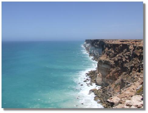 about
the height of our tent, but this part of the coastline is known for the
cliffs and lookouts that run along it. The Bunda Cliffs run along here and
the waters from the Southern Ocean, direct from Antarctica run headlong into
them. The cliffs are about 90 metres above sea level and are in part made up
from the skeletons of crustations and other marine animals from a time when
Australia was connected to, and part of Antarctica. The Bunda Cliffs are
also a National Park as is the ocean for 200 kilometres out from the land
and to 5 miles in depth at it's deepest point.
about
the height of our tent, but this part of the coastline is known for the
cliffs and lookouts that run along it. The Bunda Cliffs run along here and
the waters from the Southern Ocean, direct from Antarctica run headlong into
them. The cliffs are about 90 metres above sea level and are in part made up
from the skeletons of crustations and other marine animals from a time when
Australia was connected to, and part of Antarctica. The Bunda Cliffs are
also a National Park as is the ocean for 200 kilometres out from the land
and to 5 miles in depth at it's deepest point.
Camping at one of the lookouts would be a great way to while away a few hours but the strength of the wind would make keeping the tent in one place almost impossible.
We visited two lookouts today and at one of them found two men using their pillows as a tee while smashing golf balls off the cliff and into the ocean. They had bought the golf balls after noticing them next to the frying pan they were buying in a second hand shop so decided to practice their golf in a most spectacular place. Speaking of golf, the Nullarbor has the worlds longest golf course on it. The manager of the Balladonia Roadhouse came up with the idea back in 1970 and enlisted the other roadhouses along the way, each one putting in a single hole at which travellers can play. The course runs from Balladonia to Ceduna.
Just after 50 kilometres we were passed by the "Nullarbor Runner", the postman who delivers from Ceduna to Border Village, some 481 kilometres in length. Later, and after our stomachs told us it was time for lunch, with just over 60 kilometres done today and 104 to Nullarbor we found ourselves a nice camp spot, complete with a roof over the table at a rest area and called it a day.
Today's Stats
From: Bush Camp 20 km E of Western Australia border
To: Bush Camp 104 km W of Nullarbor
Ride Time:
5 hrs 29 mins
Distance:
64.25 km's
Av Speed:
11.6 km/h
Max Speed:
17.5 km/h
Max
Altitude:
73 m
Max Climb: 4 %
Av Climb: 1 %
Weather: Sunny 27 deg C with SE headwind
Friday 08 December 2006
Our rest area camp was a beauty and when we awoke the wind was already up ensuring that we were going to have to work for our distance today, in fact, the weather was going to play a big part in today's activities.
Our first stop was a cliff lookout where we were again afforded magnificent views of the cliffs and the southern edge of Australia and it was here that we realised exactly how strong the wind was as we gained a tailwind once we turned towards the cliffs. The last time we rode through here the wind was so strong that it blew Joanne's trike backwards, on this visit the wind was from the opposite direction and we had to take extreme care near the cliff edge as a sudden gust of wind would see us over the edge had we been too close. From the cliffs the vegetation became more of a savannah with dry lifeless grass being the major attraction and a check of the temperature at 9.30 am showed a hot 35 deg C - this would be a hot ride. There wasn't much to take our minds off the heat and the ride but we did have a laugh at a comment made by a truck driver when he was trying to explain us to another truck coming along. He described us as "two blokes on bikes, you know those that you sit on and pedal". He knew what he meant and so did we, but he just didn't get it out the way it was intended and we talked and laughed about it for some time afterwards.
After another very hot 22 kilometres later we came to
another cliff viewing area where we hoped we would find a
 shelter
over the table as we had at others, but there was none. I had been keeping
an eye on the temperature as we were riding and apart from the wind
increasing, the mercury had hit a staggering 51 deg C (123.8 deg F), and to
make things worse all of our water, bar one bag was hot enough to just dunk
a tea bag in and make a cuppa. Joanne was riding along oblivious to the
temperature as I had been monitoring it and trying to hatch a plan to get
out of it- somehow, but not telling her so as not to scare her. As we were
riding into the viewing area we were passed by a campervan. By the time we
had got to where the camper was parked the couple had had a look at the
cliffs and were back at the camper. The lady came over to chat and before
she could get the "admire you" out of "you amaze me and I admire you for
riding", I asked her "do you have any cold water?" She took one look at me,
the penny dropped and she said "come with me" and promptly gave us a 1.5
litre bottle of icy cold water from the fridge in the camper. We took a
couple of swigs and had a brief chat with her before they left and we added
some powerade powder to it and gulping it all down. The problem was what to
do now? The terrain was not going to give us any help, there was nowhere to
get out of the wind or the sun so it was time to improvise. Selecting a spot
where the salt bush could block the wind we set about using the hootchie
strung between the two trikes and with the tarp underneath we lay down
sipping water and with our bandannas soaked in water and covering our heads.
We lay there for the next 3 hours while the heat of the day passed. An
interesting point here is that during the time we were there about 6
vehicles came in and only one person came to check if we were ok. We said
the reason was that we looked like hobo's and therefore nobody wanted to
know us.
shelter
over the table as we had at others, but there was none. I had been keeping
an eye on the temperature as we were riding and apart from the wind
increasing, the mercury had hit a staggering 51 deg C (123.8 deg F), and to
make things worse all of our water, bar one bag was hot enough to just dunk
a tea bag in and make a cuppa. Joanne was riding along oblivious to the
temperature as I had been monitoring it and trying to hatch a plan to get
out of it- somehow, but not telling her so as not to scare her. As we were
riding into the viewing area we were passed by a campervan. By the time we
had got to where the camper was parked the couple had had a look at the
cliffs and were back at the camper. The lady came over to chat and before
she could get the "admire you" out of "you amaze me and I admire you for
riding", I asked her "do you have any cold water?" She took one look at me,
the penny dropped and she said "come with me" and promptly gave us a 1.5
litre bottle of icy cold water from the fridge in the camper. We took a
couple of swigs and had a brief chat with her before they left and we added
some powerade powder to it and gulping it all down. The problem was what to
do now? The terrain was not going to give us any help, there was nowhere to
get out of the wind or the sun so it was time to improvise. Selecting a spot
where the salt bush could block the wind we set about using the hootchie
strung between the two trikes and with the tarp underneath we lay down
sipping water and with our bandannas soaked in water and covering our heads.
We lay there for the next 3 hours while the heat of the day passed. An
interesting point here is that during the time we were there about 6
vehicles came in and only one person came to check if we were ok. We said
the reason was that we looked like hobo's and therefore nobody wanted to
know us.

Around 3 pm we decided that from our calculations, maps and memory, that there was a rest area with shade and a water tank about 9 kilometres from our location, and that we felt well enough to attempt the distance. So figuring the wind had abated slightly and with water hot enough to make a coffee in we rode off in search of a better place to camp and some cooler water.
Both of us were feeling sick and obviously in the first stages of a bout of heat stroke. The good thing was that we were both still sweating and both still peeing, but not for long if this kept up. The heat coming off the road was back at 50 deg C as we rode.
Some 9 kilometres later, and where we figured it was was the truck stop/rest area we had been looking for, complete with water tank. We interrupted the birds from their sipping the leaking water, filled the 2.5 litre container we use for cooking water and promptly emptied it over ourselves a number of times, bringing our bodies core temperature down and making us feel better. The sign on the tank said that the water could be contaminated and to boil it first, so we filled some containers and a water bag, dropped in a couple of purification tablets then patiently waited the 30 minutes for them to do their work before we attempted to quench an unquenchable thirst, and while doing so sat and poured water over ourselves.
Feeling slightly better we found ourselves a shady spot to cook a meal and sat there forcing food into our bodies, too tired and worn out to really want to eat it. Another shady spot out of sight from the road and we made camp and went to bed exhausted while the cool change built up in the West and the clouds put on a show for rain but didn't deliver.
Today's Stats
From: Bush Camp 104 km W of Nullarbor
To: Bush Camp 43 km W of Nullarbor Roadhouse.
Ride Time:
5 hrs 4 mins
Distance:
64.55 km's
Av Speed:
12.7 km/h
Max Speed:
20 km/h
Max
Altitude:
137 m
Max Climb: 9 %
Av Climb: 1 %
Weather: Sunny and Hot 51 deg C. N wind.
Saturday 09 December 2006
We awoke early from our deep sleep around 5.10 am to a chorus of Crows, in the trees near our tent and nearby. It is hard to sleep in with them making such a racket so a carefully aimed stone in their direction sent them scattering to the safety of the other trees where they all sat and crowed about what had just happened.
The temperature was a cool 21 deg C and we were enjoying the cool of the morning, so with the sun still tucked up in bed we packed up and prepared to ride the 43 kilometres to Nullarbor where we knew a cold chocolate milk, shower and room was awaiting us.
The grass savannah like terrain was again with us and the closer we got to Nullarbour the less of anything was around, although we did spot a dingo on the side of the road who took off a safe distance into the grass to watch us pass by. We were passed by one of the truck drivers we were chatting to at Mundrabilla and enjoyed a short conversation on the radio before we lost range, but he promised he'd see us next week and have another chat.
 We
pressed on into the side wind, each taking turns at blocking it for the
other until we came to the sign that told us we were at the Western End of
the Nullarbor, the roadhouse just a kilometre or so in the background. We
rode up to the roadhouse, parked under the roof in the car park and promptly
went inside, arranged a motel room, bought and downed a cold chocolate milk
before enjoying a shower and a rest in our room. And of course, as we sit
here, the wind has changed to a tailwind!
We
pressed on into the side wind, each taking turns at blocking it for the
other until we came to the sign that told us we were at the Western End of
the Nullarbor, the roadhouse just a kilometre or so in the background. We
rode up to the roadhouse, parked under the roof in the car park and promptly
went inside, arranged a motel room, bought and downed a cold chocolate milk
before enjoying a shower and a rest in our room. And of course, as we sit
here, the wind has changed to a tailwind!
Today's Stats
From: Bush Camp 43 km W of Nullarbor Roadhouse.
To: Nullarbor Roadhouse
Ride Time:
3 hrs 15 mins
Distance:
43.7 km's
Av Speed:
13.4 km/h
Max Speed:
18 km/h
Max
Altitude:
77 m
Max Climb: 2 %
Av Climb: 1 %
Weather: Sunny 27 deg C with SE headwind
Saturday 10 December 2006
Today is our 29th Wedding Anniversary and as one does, we celebrated in style. We left our cosy, comfortable, dry motel room with running water, table, TV and Internet connection to ride in the rain whilst playing with the trucks on the highway.
Overnight the rain had come in and the weather was more
like what we had last time, so having got up late, and debating whether or
not to go, during a
 break
in the rain we packed the trikes and headed off across the tree-less plain.
The road was wet and the wash being thrown up by the passing trucks was
enough to drown in, especially as the wind was coming from their side. We
crossed the 20 kilometres of tree-less plain, passing the turnoff to the
head of the bight which was closed for maintenance and eventually coming to
the sign indicating the eastern end. A quick photo and we were off again,
this time working our way into more wooded areas and the sand dunes which
stretch across the head of the bight.
break
in the rain we packed the trikes and headed off across the tree-less plain.
The road was wet and the wash being thrown up by the passing trucks was
enough to drown in, especially as the wind was coming from their side. We
crossed the 20 kilometres of tree-less plain, passing the turnoff to the
head of the bight which was closed for maintenance and eventually coming to
the sign indicating the eastern end. A quick photo and we were off again,
this time working our way into more wooded areas and the sand dunes which
stretch across the head of the bight.
Easily finding the spot where we camped last time we pressed on and came into the hills. A real roller coaster ride for the next 50 kilometres up and down through some very pleasant looking bush, the hills taking our mind off of the weather and the ride. Making good time courtesy of some exhilarating downhill runs we found another water tank and obtained some cooking water before going off to explore a track out the back of the rest area. Unfortunately for us all we found was a giant hole in the ground littered with old car bodies, bottles, drums, mattress wire and all manner of junk. The wind was up and camping there was not going to be pleasant so we moved on. Out of the rest area and up one of the largest hills we have climbed in a long while saw us looking for a campsite. We investigated a number of possibilities but didn't like them and eventually settled on one down an overgrown track and near an old borrow pit. We did consider going on to Yalata Roadhouse but had been told that it is closed because the managers had been ripping off the Aboriginal Mission that owns it, so there would be no camping in the caravan park like last time.

Today's Stats
From: Nullarbor Roadhouse.
To: Bush Camp 15km W of Yalata
Ride Time:
5 hrs 56 mins
Distance:
79.9 km's
Av Speed:
13.4 km/h
Max Speed:
43 km/h
Max
Altitude:
86 m
Max Climb: 8 %
Av Climb: 1 %
Weather: Rain then overcast 21 Deg C. SSE side wind.